1960s Maps of Winnebago County, Wisconsin
Explore 11 historic maps of Winnebago County from the 1960s. These maps offer a rare glimpse into what life looked like during the 1960s — showing old roads, neighborhoods, homes, and landmarks that have changed or disappeared over time.
Whether you're researching your family's past, planning a metal detecting trip, or studying how Winnebago County's landscape evolved across the 1960s, these high-resolution maps are a powerful tool for exploring the history of this region.
- Focus on a specific era: All maps on this page are from the 1960s, giving you a focused view of this time period.
- See what’s changed: Compare century-old streets, trails, and buildings to today's modern landscape using overlays and satellite layers.
- Research with precision: Use these maps for genealogy, historical research, land use analysis, or educational projects.
- View, download, or print: Maps are fully viewable online in high resolution, and can be downloaded or printed for your own records.
Start exploring Winnebago County's history through authentic maps from the 1960s. This is your window into the past.
Winnebago County, WI maps
(11)- 1960 Map of Madison
 1960 Madison1960 Print · USGSCentral and Southern Wisconsin are captured in the late fifties, showing the region as its rail-and-river network matured. Trace the paths of the Soo Line RR or locate family roots near Lake Mendota and Horicon National Wildlife Refuge.2 unique versions available
 - 1961 Map of Oshkosh, 1962 Print
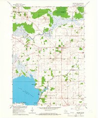
 1961 Oshkosh1962 Print · USGSOshkosh and the Fox River waterfront are captured in detail during the early sixties, showing the city's transition from a rail-heavy industrial hub to a regional educational center. Genealogists can locate family sites near Riverside Cemetery, Wisconsin State College, or the Sunny View Sanatorium.2 unique versions available
 - 1961 Map of Poy Sippi, 1963 Print
 1961 Poy Sippi1963 Print · USGSThe Lake Poygan region of Wisconsin comes alive in this early 1960s survey, showing the intricate river-and-marsh economy before modern expansion. Researchers can trace family sites at Fountain Valley Sch & Ch, the Welsh Cem, or follow the banks of the Poy Sippi River through historic lakefront settlements like Tustin.2 unique versions available
 - 1961 Map of Oshkosh, 1963 Print
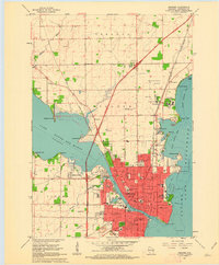
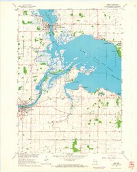
 1961 Oshkosh1963 Print · USGSThe Fox River Valley in the early sixties showcases the expansion of Oshkosh and its lakefront settlements. Genealogists and historians can trace family roots through local sites like Calvary Cem, St Peters Cem, and the Winnebago State Hospital grounds.2 unique versions available
 - 1961 Map of Lake Poygan, 1966 Print
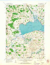
 1961 Lake Poygan1966 Print · USGSWinnebago County river life is centered on the Wolf River delta during the early sixties. Genealogists can trace family roots through numerous country landmarks including St Pauls Cem, Becker Cem, and the village of Zittau.2 unique versions available
 - 1961 Map of Oshkosh NE, 1966 Print
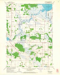
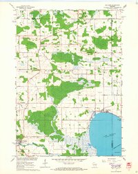
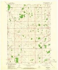 1961 Oshkosh NE1966 Print · USGSWinnebago County farm country and rail junctions are captured here in the early sixties. Researchers can trace the tracks of the Soo Line through Medina Junction and find local landmarks like Immanuel Ch, Clayton Cem, and Gillingham Sch.3 unique versions available
 - 1961 Map of Auroraville, 1966 Print
 1961 Auroraville1966 Print · USGSWisconsin's wetlands and rural townships are captured here in the early sixties as the landscape transitioned between traditional farming and specialized bog cultivation. Trace family roots at the Welsh Cem or locate old community hubs like Fountain Valley and Auroraville.2 unique versions available
 - 1961 Map of Oshkosh NW, 1966 Print
 1961 Oshkosh NW1966 Print · USGSWinnebago County in the early sixties shows a landscape of river marshes and small farming hamlets centered around Winchester and Larsen. Genealogists and local historians can locate early family burials at Royer Cem and Bell Cem or trace the rural school districts at Mathison Sch.2 unique versions available
 - 1961 Map of Eureka, 1966 Print
 1961 Eureka1966 Print · USGSWinnebago County townships like Poygan and Rushford are captured in the early sixties as a network of river-side farms and rural schools. Researchers can trace family roots through several local landmarks like Oak Hill Cem and Liberty Sch.2 unique versions available
 - 1961 Map of Omro, 1966 Print
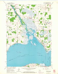
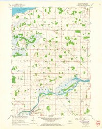
 1961 Omro1966 Print · USGSThe confluence of the Wolf and Fox Rivers defines this corner of Wisconsin in the early sixties. Genealogists and historians can trace lakeside settlements like Rivermoor or find rural landmarks such as Pingry Sch and the Omro Union Cem.2 unique versions available
 - 1961 Map of Poy Sippi, 1968 Print
 1961 Poy Sippi1968 Print · USGSThe marshlands and crossroads of Waushara County are captured here in the early 1960s as they meet the shores of Lake Poygan. Researchers can locate historic rural centers like Poy Sippi and Tustin, alongside parish sites like Emmaus Ch and St Johns Sch.2 unique versions available
End of results
Showing maps 1-11 of 11
Top cities of Winnebago County
- Oshkosh historical maps
- Neenah historical maps
- Fox Crossing historical maps
- Omro historical maps
- Black Wolf historical maps
- Winneconne historical maps
See more
Frequently asked questions
- What are the different types of historical maps available for Winnebago County?
- What is the oldest map of Winnebago County?
- Where can I purchase historical maps of Winnebago County for my home or office?
- Where can I download high-res historical maps of Winnebago County?
- Are there historical topographic maps available for Winnebago County?
- Is there historical aerial imagery available for Winnebago County?
- Where are historical maps of Winnebago County sourced from?