1970s Maps of Winnebago County, Wisconsin
Explore 2 historic maps of Winnebago County from the 1970s. These maps offer a rare glimpse into what life looked like during the 1970s — showing old roads, neighborhoods, homes, and landmarks that have changed or disappeared over time.
Whether you're researching your family's past, planning a metal detecting trip, or studying how Winnebago County's landscape evolved across the 1970s, these high-resolution maps are a powerful tool for exploring the history of this region.
- Focus on a specific era: All maps on this page are from the 1970s, giving you a focused view of this time period.
- See what’s changed: Compare century-old streets, trails, and buildings to today's modern landscape using overlays and satellite layers.
- Research with precision: Use these maps for genealogy, historical research, land use analysis, or educational projects.
- View, download, or print: Maps are fully viewable online in high resolution, and can be downloaded or printed for your own records.
Start exploring Winnebago County's history through authentic maps from the 1970s. This is your window into the past.
Winnebago County, WI maps
(2)- 1974 Map of Fahrney Point, 1978 Print
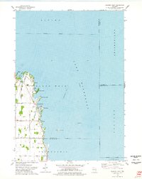 1974 Fahrney Point1978 Print · USGSThe western shores of Lake Winnebago are captured here in the mid-1970s, showing a mix of established lakeside retreats and expanding rural road networks. Trace the development of waterfront communities like Point Comfort and Decorah Beach or locate family-named landmarks such as Oaklawn Cem and the Jesuit Retreat.
 - 1974 Map of Indian Point, 1978 Print
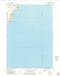 1974 Indian Point1978 Print · USGSThe western shores of Lake Winnebago are captured here in the mid-seventies, showing the intersection of lakeside life and residential growth. Genealogists and local historians can trace shoreline developments at Osh-O-Nee Shores, Paynes Point, and Island Park.
End of results
Showing maps 1-2 of 2
Top cities of Winnebago County
- Oshkosh historical maps
- Neenah historical maps
- Fox Crossing historical maps
- Omro historical maps
- Black Wolf historical maps
- Winneconne historical maps
See more
Frequently asked questions
- What are the different types of historical maps available for Winnebago County?
- What is the oldest map of Winnebago County?
- Where can I purchase historical maps of Winnebago County for my home or office?
- Where can I download high-res historical maps of Winnebago County?
- Are there historical topographic maps available for Winnebago County?
- Is there historical aerial imagery available for Winnebago County?
- Where are historical maps of Winnebago County sourced from?