1970s Maps of Wood County, Wisconsin
Explore 16 historic maps of Wood County from the 1970s. These maps offer a rare glimpse into what life looked like during the 1970s — showing old roads, neighborhoods, homes, and landmarks that have changed or disappeared over time.
Whether you're researching your family's past, planning a metal detecting trip, or studying how Wood County's landscape evolved across the 1970s, these high-resolution maps are a powerful tool for exploring the history of this region.
- Focus on a specific era: All maps on this page are from the 1970s, giving you a focused view of this time period.
- See what’s changed: Compare century-old streets, trails, and buildings to today's modern landscape using overlays and satellite layers.
- Research with precision: Use these maps for genealogy, historical research, land use analysis, or educational projects.
- View, download, or print: Maps are fully viewable online in high resolution, and can be downloaded or printed for your own records.
Start exploring Wood County's history through authentic maps from the 1970s. This is your window into the past.
Wood County, WI maps
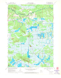
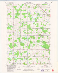
(16)- 1970 Map of Kellner, 1972 Print
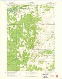 1970 Kellner1972 Print · USGSThe rural border of Wood and Portage Counties was a landscape of managed waterways and rail lines in the 1970s. Genealogists and local historians can trace the community around Kellner, finding landmarks like St Johns Cem, Grant Sch, and the Church of God.
 - 1970 Map of City Point NE, 1972 Print
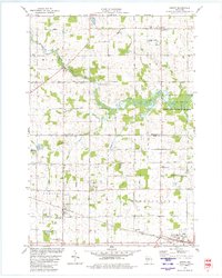
 1970 City Point NE1972 Print · USGSThe Wood County marshlands and the settlement of Sherwood are captured here in the early 1970s. Researchers can trace the drainage of Ammundson Marsh or locate the Cranberry Bog and Sherwood Lake recreation area.2 unique versions available
 - 1970 Map of Junction City, 1972 Print
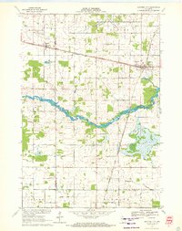 1970 Junction City1972 Print · USGSJunction City and Milladore sit at a vital rail crossing in central Wisconsin as the seventies began. Genealogists and rail historians can trace the intersection of the Soo Line and Chicago Milwaukee St Paul and Pacific, alongside local landmarks like St Wenceslaus Cem and Fogarty Marsh.
 - 1970 Map of Mather, 1972 Print
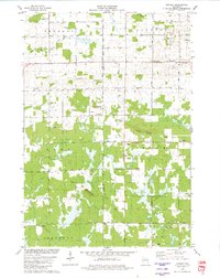
 1970 Mather1972 Print · USGSThe cranberry bogs and flowages of Juneau County are at their peak development in this 1970s record of the central Wisconsin marshes. Genealogists and historians can locate Mather, the Oak Grove Cem, and the old rail-aligned settlement of Norway Ridge.
 - 1970 Map of City Point, 1972 Print
 1970 City Point1972 Print · USGSWood County’s cranberry country and rail history are well-preserved here in the early seventies, centered on the junction at City Point. Researchers can trace the legacy of local families through the Martyrs Cem City Point Cem and the complex drainage of the Remington Ditch and Bissig Ditch.3 unique versions available
 - 1970 Map of Honey Island, 1972 Print
 1970 Honey Island1972 Print · USGSThe Marathon and Wood County borderlands appear here in the early 1970s, showcasing the extensive flowage systems of the George W Mead State Wildlife Management Area. Genealogists and local historians can trace family locations near Rangeline, Townhall, and the Cem Grace Ch.
 - 1970 Map of Sherry, 1972 Print
 1970 Sherry1972 Print · USGSWood County dairy country and rail corridors are captured here in the early seventies, as the region maintained its rural character. Local historians can trace the paths of the Soo Line and Chicago and North Western through Sherry and Blenker.2 unique versions available
 - 1970 Map of Rocky Run, 1972 Print
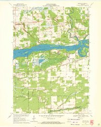
 1970 Rocky Run1972 Print · USGSThe Wisconsin River valley on the Portage and Wood county border comes to life in the early seventies, showing a landscape defined by water and woods. Genealogists and local historians can locate the Mill Creek Community, the Buelow Cem, and the marshy reaches of Fogarty Marsh.2 unique versions available
 - 1970 Map of Meehan, 1972 Print
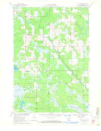
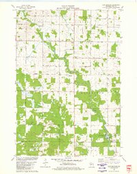
 1970 Meehan1972 Print · USGSPortage County at the start of the seventies reveals a landscape defined by the expansive Wisconsin River Flowage and specialized agriculture. Researchers can locate the settlement of Meehan, the Linwood Union Cem, and regional landmarks like the Cranberry Bog.2 unique versions available
 - 1970 Map of Big Eau Pleine Reservoir, 1984 Print
 1970 Big Eau Pleine Reservoir1984 Print · USGSMarathon and Portage counties were defined by extensive wetland management and conservation efforts in the early seventies. Genealogists and outdoorsmen can trace landmarks like Runkle Cem, Big Eau Pleine County Park, and the winding Little Eau Pleine River.
 - 1979 Map of Marshfield, 1980 Print
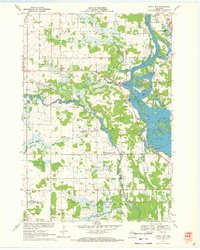
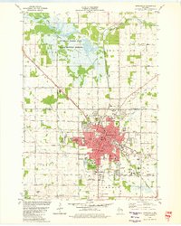 1979 Marshfield1980 Print · USGSMarshfield thrived as a central Wisconsin rail and education hub during the late seventies. Researchers can trace the path of the Soo Line and Chicago and North Western railroads, or locate family sites near Hillside Cem and St Peters Ch.
 - 1979 Map of Lindsey, 1980 Print
 1979 Lindsey1980 Print · USGSThe central Wisconsin borderlands of Wood and Clark Counties come into focus in the late 1970s, showing a landscape of sprawling wetlands and small rural settlements. Genealogists can locate family landmarks like the Nasonville Sch, Rock Cem, and the village of Lindsey.
 - 1979 Map of Arpin, 1980 Print
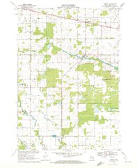
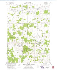 1979 Arpin1980 Print · USGSWood County dairy and quarrying country comes into focus in the late seventies, showing the rural landscapes around Arpin and Bethel. Genealogists and historians can locate numerous burial sites including Indian Bill Cem and Slidre Cem or trace the paths of the SOO LINE and CHICAGO AND NORTH WESTERN railroads.
 - 1979 Map of Lake Manakiki, 1980 Print
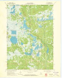
 1979 Lake Manakiki1980 Print · USGSWood County’s rural townships and river bends are captured here in the late seventies. Genealogists and local historians can trace family-named roads like Thompson Road and locate burial sites at Trinity Cem or Richfield Cem.
 - 1979 Map of Spencer South, 1980 Print
 1979 Spencer South1980 Print · USGSCentral Wisconsin farmland and wetlands are documented here in the late seventies, showing the rural communities of Spencer and Chili. Researchers can trace the Soo Line corridor and locate local landmarks like St Stephens Ch and the Mc Millan Marsh.
 - 1979 Map of Hewitt, 1980 Print
 1979 Hewitt1980 Print · USGSThe Wood and Marathon County border country is captured here in the late seventies, showing the traditional rail-and-road layout of central Wisconsin. Family historians can locate numerous rural burial grounds like St Michaels Cem and Auburndale Cem, or trace the winding Little Eau Pleine River.
End of results
Showing maps 1-16 of 16
Top cities of Wood County
- Marshfield historical maps
- Wisconsin Rapids historical maps
- Nekoosa historical maps
- Port Edwards historical maps
- Pittsville historical maps
- Biron historical maps
See more
Frequently asked questions
- What are the different types of historical maps available for Wood County?
- What is the oldest map of Wood County?
- Where can I purchase historical maps of Wood County for my home or office?
- Where can I download high-res historical maps of Wood County?
- Are there historical topographic maps available for Wood County?
- Is there historical aerial imagery available for Wood County?
- Where are historical maps of Wood County sourced from?