1970s Maps of Cary, Wisconsin
Explore 3 historic maps of Cary from the 1970s. These maps offer a rare glimpse into what life looked like during the 1970s — showing old roads, neighborhoods, homes, and landmarks that have changed or disappeared over time.
Whether you're researching your family's past, planning a metal detecting trip, or studying how Cary's landscape evolved across the 1970s, these high-resolution maps are a powerful tool for exploring the history of this region.
- Focus on a specific era: All maps on this page are from the 1970s, giving you a focused view of this time period.
- See what’s changed: Compare century-old streets, trails, and buildings to today's modern landscape using overlays and satellite layers.
- Research with precision: Use these maps for genealogy, historical research, land use analysis, or educational projects.
- View, download, or print: Maps are fully viewable online in high resolution, and can be downloaded or printed for your own records.
Start exploring Cary's history through authentic maps from the 1970s. This is your window into the past.
Cary, WI maps
(3)- 1970 Map of City Point NE, 1972 Print
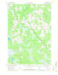 1970 City Point NE1972 Print · USGSThe Wood County marshlands and the settlement of Sherwood are captured here in the early 1970s. Researchers can trace the drainage of Ammundson Marsh or locate the Cranberry Bog and Sherwood Lake recreation area.2 unique versions available
 - 1979 Map of Lindsey, 1980 Print
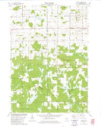 1979 Lindsey1980 Print · USGSThe central Wisconsin borderlands of Wood and Clark Counties come into focus in the late 1970s, showing a landscape of sprawling wetlands and small rural settlements. Genealogists can locate family landmarks like the Nasonville Sch, Rock Cem, and the village of Lindsey.
 - 1979 Map of Lake Manakiki, 1980 Print
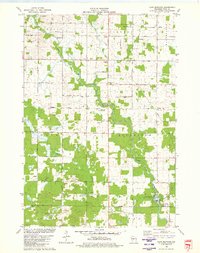 1979 Lake Manakiki1980 Print · USGSWood County’s rural townships and river bends are captured here in the late seventies. Genealogists and local historians can trace family-named roads like Thompson Road and locate burial sites at Trinity Cem or Richfield Cem.
End of results
Showing maps 1-3 of 3
Top cities near Cary
- Marshfield historical maps
- McMillan historical maps
- Pittsville historical maps
- Lynn historical maps
- Granton historical maps
- Arpin historical maps
See more
Frequently asked questions
- What are the different types of historical maps available for Cary?
- What is the oldest map of Cary?
- Where can I purchase historical maps of Cary for my home or office?
- Where can I download high-res historical maps of Cary?
- Are there historical topographic maps available for Cary?
- Is there historical aerial imagery available for Cary?
- Where are historical maps of Cary sourced from?