1960s Maps of Laramie, Wyoming
Explore 2 historic maps of Laramie from the 1960s. These maps offer a rare glimpse into what life looked like during the 1960s — showing old roads, neighborhoods, homes, and landmarks that have changed or disappeared over time.
Whether you're researching your family's past, planning a metal detecting trip, or studying how Laramie's landscape evolved across the 1960s, these high-resolution maps are a powerful tool for exploring the history of this region.
- Focus on a specific era: All maps on this page are from the 1960s, giving you a focused view of this time period.
- See what’s changed: Compare century-old streets, trails, and buildings to today's modern landscape using overlays and satellite layers.
- Research with precision: Use these maps for genealogy, historical research, land use analysis, or educational projects.
- View, download, or print: Maps are fully viewable online in high resolution, and can be downloaded or printed for your own records.
Start exploring Laramie's history through authentic maps from the 1960s. This is your window into the past.
Laramie, WY maps
(2)- 1963 Map of Laramie, 1964 Print
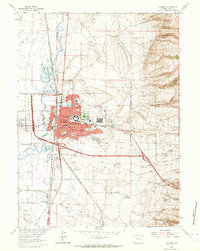 1963 Laramie1964 Print · USGSLaramie and its western neighbor are captured here in the early sixties, as the university campus and residential neighborhoods expanded toward the foothills. Genealogists and local historians can trace the Ft Sanders (Site), numerous neighborhood schools like Nellie Iles Sch, and the local Cement Plant.3 unique versions available
 - 1963 Map of Laramie SW, 1965 Print
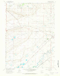 1963 Laramie SW1965 Print · USGSAlbany County ranchlands and university research farms are documented here during the early sixties. Researchers can trace the Union Pacific line, find the Cem near the river, and locate historic sites like the Univ of Wyo Dairy Farm.2 unique versions available
End of results
Showing maps 1-2 of 2
Top neighborhoods of Laramie
- Tree Area historical maps
- West Laramie historical maps
- West Side historical maps
- Alta Vista historical maps
- CPL historical maps
- Corthell Hills historical maps
See more
Frequently asked questions
- What are the different types of historical maps available for Laramie?
- What is the oldest map of Laramie?
- Where can I purchase historical maps of Laramie for my home or office?
- Where can I download high-res historical maps of Laramie?
- Are there historical topographic maps available for Laramie?
- Is there historical aerial imagery available for Laramie?
- Where are historical maps of Laramie sourced from?