1900s (20th Century) Maps of Little Medicine, Wyoming
Explore 5 historic maps of Little Medicine from the 1900s (20th Century). These maps offer a rare glimpse into what life looked like during the 1900s — showing old roads, neighborhoods, homes, and landmarks that have changed or disappeared over time.
Whether you're researching your family's past, planning a metal detecting trip, or studying how Little Medicine's landscape evolved across the 1900s, these high-resolution maps are a powerful tool for exploring the history of this region.
- Focus on a specific era: All maps on this page are from the 1900s, giving you a focused view of this time period.
- See what’s changed: Compare century-old streets, trails, and buildings to today's modern landscape using overlays and satellite layers.
- Research with precision: Use these maps for genealogy, historical research, land use analysis, or educational projects.
- View, download, or print: Maps are fully viewable online in high resolution, and can be downloaded or printed for your own records.
Start exploring Little Medicine's history through authentic maps from the 1900s. This is your window into the past.
Little Medicine, WY maps
(5)- 1954 Map of Torrington, 1963 Print
 1954 Torrington1963 Print · USGSEastern Wyoming and the Nebraska borderlands are captured here during the mid-fifties, showing a landscape shaped by the Platte River and the Laramie Range. Researchers can trace deep history at the Fort Laramie National Historical Site, the Old Doty Ranch Site, and along the Old Fetterman Road.4 unique versions available
 - 1958 Map of Torrington
 1958 Torrington1958 Print · USGSEastern Wyoming and the Nebraska borderlands are captured in the late fifties, showcasing a landscape of high plains ranching and river-fed industry. Trace the historic paths of the Union Pacific railroad and find legacy sites like Fort Laramie and Sunrise.
 - 1964 Map of Rock Creek, 1968 Print
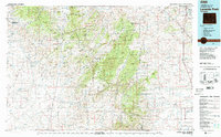
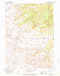 1964 Rock Creek1968 Print · USGSThe high plains of Converse and Albany counties are captured here in the mid-1960s, a landscape defined by ranching trails and the Medicine Bow National Forest boundary. Researchers can trace the remote Russells Camp and follow the intricate forks of the North Fork Little Medicine Bow River.2 unique versions available
 - 1981 Map of Laramie Peak
 1981 Laramie Peak1981 Print · USGSThe Laramie Mountains and Medicine Bow National Forest define this landscape in the early eighties. Genealogists and historians can trace high-country settlements like Toltec and Binford, or locate industrial sites like the Mica Mine near the North Laramie River.2 unique versions available
 - 1992 Map of Rock Creek, 1996 Print
 1992 Rock Creek1996 Print · USGSThe high-country border of Converse and Albany Counties is shown here in the early nineties as a network of vital mountain springs and headwaters. Researchers can trace remote locales like Russells Camp and Whiskey Springs or follow the path of the Little Medicine Bow River.
End of results
Showing maps 1-5 of 5
Frequently asked questions
- What are the different types of historical maps available for Little Medicine?
- What is the oldest map of Little Medicine?
- Where can I purchase historical maps of Little Medicine for my home or office?
- Where can I download high-res historical maps of Little Medicine?
- Are there historical topographic maps available for Little Medicine?
- Is there historical aerial imagery available for Little Medicine?
- Where are historical maps of Little Medicine sourced from?