1900s (20th Century) Maps of Meadow Lark Lake, Wyoming
Explore 9 historic maps of Meadow Lark Lake from the 1900s (20th Century). These maps offer a rare glimpse into what life looked like during the 1900s — showing old roads, neighborhoods, homes, and landmarks that have changed or disappeared over time.
Whether you're researching your family's past, planning a metal detecting trip, or studying how Meadow Lark Lake's landscape evolved across the 1900s, these high-resolution maps are a powerful tool for exploring the history of this region.
- Focus on a specific era: All maps on this page are from the 1900s, giving you a focused view of this time period.
- See what’s changed: Compare century-old streets, trails, and buildings to today's modern landscape using overlays and satellite layers.
- Research with precision: Use these maps for genealogy, historical research, land use analysis, or educational projects.
- View, download, or print: Maps are fully viewable online in high resolution, and can be downloaded or printed for your own records.
Start exploring Meadow Lark Lake's history through authentic maps from the 1900s. This is your window into the past.
Meadow Lark Lake, WY maps
(9)- 1901 Map of Cloud Peak
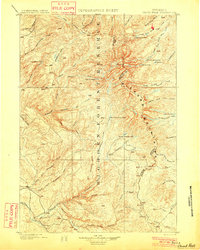 1901 Cloud Peak1901 Print · USGSThe high alpine country of the Big Horn range is captured here at the turn of the century just after its designation as a Forest Reserve. Researchers can trace the rugged headwaters of the Powder River and find remote landmarks like Lake Solitude, Black Butte, and Cloud Peak Lake.7 unique versions available
 - 1955 Map of Sheridan, 1973 Print
 1955 Sheridan1973 Print · USGSThe Bighorn Mountains meet the Powder River Basin in the 1950s, a period when cattle ranching and coal mining defined the regional economy. Genealogists and historians can trace local landmarks like the Fort Mackenzie Veteran Hospital, the Monarch Coal Mine, and legacy operations such as the Beckton Stock Farm.2 unique versions available
 - 1958 Map of Sheridan
 1958 Sheridan1958 Print · USGSThe Bighorn Mountains meet the high plains in the mid-1950s, revealing a landscape of large-scale ranching and mineral extraction. Trace the legacy of early settlements and industry through the Kleenburn Coal Tipple, Beckton Stock Farm, and the Hidden Dome Oil & Gas Field.2 unique versions available
 - 1962 Map of Sheridan
 1962 Sheridan1962 Print · USGSThe Big Horn Mountains and Powder River country are captured here in the early sixties as energy production and ranching shaped northern Wyoming. Researchers can locate specific sites like the Kleenburn Coal Tipple, Eaton Bros Ranch, and the Fort McKenzie Veteran Hospital.
 - 1967 Map of Brokenback Narrows, 1971 Print
 1967 Brokenback Narrows1971 Print · USGSBig Horn and Washakie counties are captured in the late sixties, showing a landscape of forest service outposts and cattle range management. Trace high-country routes to Buck Creek Cow Camp, Tyrrell Ranger Sta, or the dramatic geology of Brokenback Narrows.
 - 1967 Map of Meadowlark Lake, 1971 Print
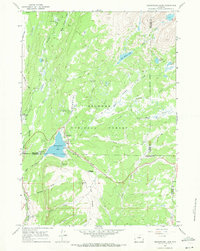 1967 Meadowlark Lake1971 Print · USGSBig Horn Mountain recreation and forest management are in full view during the late sixties. Researchers can trace the development of the Meadowlark Ski Area and remote seasonal outposts like Deer Haven Lodge or the Tyrrell Ranger Station.3 unique versions available
 - 1979 Map of Worland
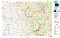 1979 Worland1979 Print · USGSThe Bighorn Basin in the late seventies reveals a landscape of river-valley agriculture and high-mountain wilderness. Researchers can trace the energy-driven growth of Worland and Ten Sleep, or locate family landmarks near Hyattville and the Big Horn Mine.2 unique versions available
 - 1993 Map of Meadowlark Lake, 1997 Print
 1993 Meadowlark Lake1997 Print · USGSBighorn National Forest high country comes to life in the early nineties as recreation and forestry intersect. Outdoor historians and genealogists can trace family-named sites and mountain outposts like Meadowlark Lodge, the Tyrell Ranger Sta, and St Christopher in the Bighorn.
 - 1993 Map of Brokenback Narrows, 1997 Print
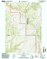 1993 Brokenback Narrows1997 Print · USGSThe Big Horn National Forest high country during the 1990s reveals a landscape of administrative outposts and deep canyons. Researchers can trace remote trails to Soldier Creek Camp, the Brokenback Narrows, and isolated landmarks like Lone Tree Spring.2 unique versions available
End of results
Showing maps 1-9 of 9
Frequently asked questions
- What are the different types of historical maps available for Meadow Lark Lake?
- What is the oldest map of Meadow Lark Lake?
- Where can I purchase historical maps of Meadow Lark Lake for my home or office?
- Where can I download high-res historical maps of Meadow Lark Lake?
- Are there historical topographic maps available for Meadow Lark Lake?
- Is there historical aerial imagery available for Meadow Lark Lake?
- Where are historical maps of Meadow Lark Lake sourced from?