
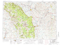
1955 Map of Sheridan
USGS Topo · Published 1973About this map
Bighorn National Forest dominates the central landscape of this mid-century survey, rising to the heights of Cloud Peak and Black Mountain. Along the eastern slopes, the city of Sheridan and the town of Buffalo serve as anchors for a region defined by ranching and resource extraction. The presence of the Beckton Stock Farm, Paradise Ranch, and Saddlestring Dude Ranch reflects the area's transition into a destination for recreation and livestock, while the Fort Mackenzie Veteran Hospital and Wyoming Soldiers and Sailors Home highlight the established social infrastructure of Sheridan County.
Find a feature on this map
79 named features on this map. Tap any name to fly to it.
Don’t see what you’re looking for? This feature index may not catch every label — zoom into the map to look around manually.
Map Details
Editions of this 1955 Sheridan Map
2 editions found
Other maps of this area

1894 · Rosebud
USGS Topo · 1:125,000

1894 · St. Xavier
USGS Topo · 1:125,000

1895 · Dayton
USGS Topo · 1:125,000

1898 · Bald Mountain
USGS Topo · 1:125,000

1899 · Cloud peak
USGS Topo · 1:125,000

1900 · Fort McKinney
USGS Topo · 1:125,000

1901 · Rosebud
USGS Topo · 1:125,000

1901 · Cloud Peak
USGS Topo · 1:125,000

1901 · Dayton
USGS Topo · 1:125,000

1901 · St. Xavier
USGS Topo · 1:125,000