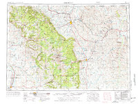
1955 Map of Sheridan
USGS Topo · Published 1976About this map
The Bighorn Mountains dominate the western horizon of this mid-century landscape, crowned by the high summit of Cloud Peak. Along the eastern slopes, the Chicago Burlington and Quincy RR connects coal mining operations near Monarch and Kleenburn with the regional hub of Sheridan. The map reveals an economy tied to both the extraction of natural resources and the established ranching traditions of northern Wyoming.
Find a feature on this map
57 named features on this map. Tap any name to fly to it.
Don’t see what you’re looking for? This feature index may not catch every label — zoom into the map to look around manually.
Map Details
Editions of this 1955 Sheridan Map
2 editions found

Other maps of this area

1894 · Rosebud
USGS Topo · 1:125,000

1894 · St. Xavier
USGS Topo · 1:125,000

1895 · Dayton
USGS Topo · 1:125,000

1898 · Bald Mountain
USGS Topo · 1:125,000

1899 · Cloud peak
USGS Topo · 1:125,000

1900 · Fort McKinney
USGS Topo · 1:125,000

1901 · Rosebud
USGS Topo · 1:125,000

1901 · Cloud Peak
USGS Topo · 1:125,000

1901 · Dayton
USGS Topo · 1:125,000

1901 · St. Xavier
USGS Topo · 1:125,000