1970s Maps of Wright, Wyoming
Explore 3 historic maps of Wright from the 1970s. These maps offer a rare glimpse into what life looked like during the 1970s — showing old roads, neighborhoods, homes, and landmarks that have changed or disappeared over time.
Whether you're researching your family's past, planning a metal detecting trip, or studying how Wright's landscape evolved across the 1970s, these high-resolution maps are a powerful tool for exploring the history of this region.
- Focus on a specific era: All maps on this page are from the 1970s, giving you a focused view of this time period.
- See what’s changed: Compare century-old streets, trails, and buildings to today's modern landscape using overlays and satellite layers.
- Research with precision: Use these maps for genealogy, historical research, land use analysis, or educational projects.
- View, download, or print: Maps are fully viewable online in high resolution, and can be downloaded or printed for your own records.
Start exploring Wright's history through authentic maps from the 1970s. This is your window into the past.
Wright, WY maps
(3)- 1971 Map of Reno Junction, 1974 Print
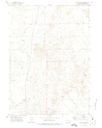 1971 Reno Junction1974 Print · USGSCampbell County ranching and early energy development are captured here in the early seventies, centered on the crossroads of Reno Junction. Genealogists and historians can locate family sites like Durham Ranch and Boller Ranch or trace the drainage of School Section Draw.
 - 1971 Map of Little Thunder Reservoir, 1974 Print
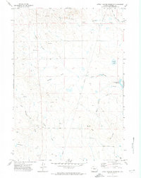 1971 Little Thunder Reservoir1974 Print · USGSCampbell County ranching and energy land is captured here in the early seventies before modern development altered the prairie. Genealogists and historians can locate the Highway Sch, St Francis Ch, and family landmarks like Stuart Ranch.2 unique versions available
 - 1974 Map of Reno Junction, 1975 Print
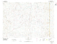 1974 Reno Junction1975 Print · USGSThe high plains of eastern Wyoming in the mid-1970s reveal an era of intensive energy production and remote ranching life. Genealogists and historians can trace the footprint of petroleum industry landmarks like the Hilight Oil and Gas Field alongside old settlements like Savageton and Reno.2 unique versions available
End of results
Showing maps 1-3 of 3
Top neighborhoods of Wright
Frequently asked questions
- What are the different types of historical maps available for Wright?
- What is the oldest map of Wright?
- Where can I purchase historical maps of Wright for my home or office?
- Where can I download high-res historical maps of Wright?
- Are there historical topographic maps available for Wright?
- Is there historical aerial imagery available for Wright?
- Where are historical maps of Wright sourced from?