1980s Maps of Baggs, Wyoming
Explore 3 historic maps of Baggs from the 1980s. These maps offer a rare glimpse into what life looked like during the 1980s — showing old roads, neighborhoods, homes, and landmarks that have changed or disappeared over time.
Whether you're researching your family's past, planning a metal detecting trip, or studying how Baggs's landscape evolved across the 1980s, these high-resolution maps are a powerful tool for exploring the history of this region.
- Focus on a specific era: All maps on this page are from the 1980s, giving you a focused view of this time period.
- See what’s changed: Compare century-old streets, trails, and buildings to today's modern landscape using overlays and satellite layers.
- Research with precision: Use these maps for genealogy, historical research, land use analysis, or educational projects.
- View, download, or print: Maps are fully viewable online in high resolution, and can be downloaded or printed for your own records.
Start exploring Baggs's history through authentic maps from the 1980s. This is your window into the past.
Baggs, WY maps
(3)- 1982 Map of Baggs, 1983 Print
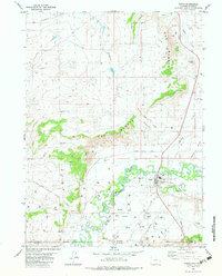 1982 Baggs1983 Print · USGSThe riverfront town of Baggs and its borderlands are shown in the early eighties as energy development transformed the valley. Researchers can trace local landmarks like Ledford, the Little Snake River, and the industrial sites at Gravel Pits.
 - 1983 Map of Baggs
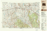
 1983 Baggs1983 Print · USGSSettlement along the Wyoming-Colorado border in the early eighties follows the path of the Little Snake River through Carbon and Moffat counties. Researchers can trace the path of the Overland Trail or locate historical mining sites like the Ferris-Haggarty Mine and Standard Mine.
 - 1988 Map of Rawlins
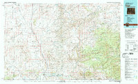
 1988 Rawlins1988 Print · USGSSouthern Wyoming and the Colorado borderlands are detailed here in the late eighties, featuring the intersection of the historic Overland Trail and the Union Pacific. Researchers can trace old rail towns like Medicine Bow and Wamsutter or landmark peaks like Medicine Bow Peak.
End of results
Showing maps 1-3 of 3
Top cities near Baggs
Frequently asked questions
- What are the different types of historical maps available for Baggs?
- What is the oldest map of Baggs?
- Where can I purchase historical maps of Baggs for my home or office?
- Where can I download high-res historical maps of Baggs?
- Are there historical topographic maps available for Baggs?
- Is there historical aerial imagery available for Baggs?
- Where are historical maps of Baggs sourced from?