1900s (20th Century) Maps of Riverton, Wyoming
Explore 6 historic maps of Riverton from the 1900s (20th Century). These maps offer a rare glimpse into what life looked like during the 1900s — showing old roads, neighborhoods, homes, and landmarks that have changed or disappeared over time.
Whether you're researching your family's past, planning a metal detecting trip, or studying how Riverton's landscape evolved across the 1900s, these high-resolution maps are a powerful tool for exploring the history of this region.
- Focus on a specific era: All maps on this page are from the 1900s, giving you a focused view of this time period.
- See what’s changed: Compare century-old streets, trails, and buildings to today's modern landscape using overlays and satellite layers.
- Research with precision: Use these maps for genealogy, historical research, land use analysis, or educational projects.
- View, download, or print: Maps are fully viewable online in high resolution, and can be downloaded or printed for your own records.
Start exploring Riverton's history through authentic maps from the 1900s. This is your window into the past.
Riverton, WY maps
(6)- 1950 Map of Riverton East, 1952 Print
 1950 Riverton East1952 Print · USGSFremont County settlement and irrigation come alive in the early fifties, centering on the eastern outskirts of the reservation. Genealogists and researchers can trace local landmarks like Delfelder Hall, the Penitentiary Farm, and the Chicago and Northwestern rail line.3 unique versions available
 - 1951 Map of Riverton West, 1953 Print
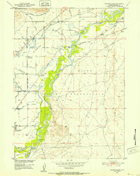
 1951 Riverton West1953 Print · USGSFremont County irrigation and rail networks take center stage in the early fifties as the Wind River valley expands. Genealogists can locate Mountain View Cem and the Wyoming Penitentiary Farm near the bustling streets of Riverton.
 - 1955 Map of Thermopolis, 1969 Print
 1955 Thermopolis1969 Print · USGSMid-century Wyoming comes alive in this survey of the Wind River basin and the high Absaroka peaks. Trace the roots of oil and water development through the Hamilton Dome Oil Field and the Boysen Reservoir, or locate local landmarks like the Wyoming Industrial Institute and St. Stephens.2 unique versions available
 - 1958 Map of Thermopolis
 1958 Thermopolis1958 Print · USGSThe Bighorn Basin and Wind River Reservation are shown here in the late fifties, during a period of significant petroleum and agricultural growth. Genealogists and historians can trace rail-towns like Gebo, energy hubs like the Hamilton Dome Oil Field, and the layout of Fort Washakie.2 unique versions available
 - 1959 Map of Riverton West, 1961 Print
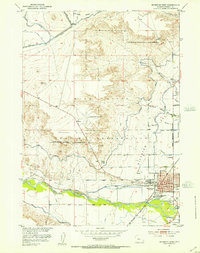
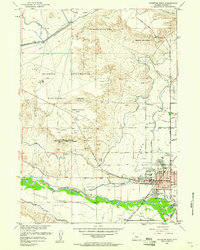 1959 Riverton West1961 Print · USGSMid-century Riverton emerges as a hub of Wyoming irrigation and rail transport during this era of federal reclamation. Genealogists and local historians can locate early civic landmarks like Ashgrove Sch, the Odd Fellows Cem, and the Fremont County Fairground.2 unique versions available
 - 1962 Map of Thermopolis
 1962 Thermopolis1962 Print · USGSThe Wind River and Bighorn basins are meticulously mapped in the early sixties, showing the vital irrigation and rail networks of the era. Genealogists and historians can locate specific landmarks like the Duncan Ranch School, the Wyoming Industrial Institute, and the Hamilton Dome oil field.
End of results
Showing maps 1-6 of 6
Top cities near Riverton
Frequently asked questions
- What are the different types of historical maps available for Riverton?
- What is the oldest map of Riverton?
- Where can I purchase historical maps of Riverton for my home or office?
- Where can I download high-res historical maps of Riverton?
- Are there historical topographic maps available for Riverton?
- Is there historical aerial imagery available for Riverton?
- Where are historical maps of Riverton sourced from?