1900s (20th Century) Maps of Shoshoni, Wyoming
Explore 8 historic maps of Shoshoni from the 1900s (20th Century). These maps offer a rare glimpse into what life looked like during the 1900s — showing old roads, neighborhoods, homes, and landmarks that have changed or disappeared over time.
Whether you're researching your family's past, planning a metal detecting trip, or studying how Shoshoni's landscape evolved across the 1900s, these high-resolution maps are a powerful tool for exploring the history of this region.
- Focus on a specific era: All maps on this page are from the 1900s, giving you a focused view of this time period.
- See what’s changed: Compare century-old streets, trails, and buildings to today's modern landscape using overlays and satellite layers.
- Research with precision: Use these maps for genealogy, historical research, land use analysis, or educational projects.
- View, download, or print: Maps are fully viewable online in high resolution, and can be downloaded or printed for your own records.
Start exploring Shoshoni's history through authentic maps from the 1900s. This is your window into the past.
Shoshoni, WY maps
(8)- 1951 Map of Hidden Valley, 1953 Print
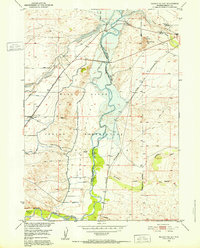 1951 Hidden Valley1953 Print · USGSCentral Wyoming's river-driven development is on full display in the early fifties, showcasing the intricate irrigation networks of the Wind River Indian Reservation. Researchers can trace the path of the Chicago and Northwestern railroad and locate landmarks like the Valley View Store and Water Tank Hill.
 - 1951 Map of Bonneville, 1953 Print
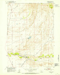 1951 Bonneville1953 Print · USGSFremont County settlement and industry are centered on the railroad junction at Bonneville in the early 1950s. Researchers can trace the intersection of the Chicago Burlington and Quincy and the Chicago and North Western near Siddons.
 - 1951 Map of Shoshoni, 1953 Print
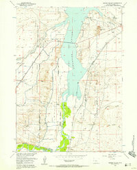
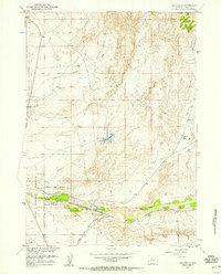
 1951 Shoshoni1953 Print · USGSShoshoni sits at a vital railroad junction in the early fifties, serving as a hub for the Chicago and North Western line. Researchers can trace the Carver Homestead and water sources like Muskrat Creek and Dry Cheyenne Creek.2 unique versions available
 - 1955 Map of Thermopolis, 1969 Print
 1955 Thermopolis1969 Print · USGSMid-century Wyoming comes alive in this survey of the Wind River basin and the high Absaroka peaks. Trace the roots of oil and water development through the Hamilton Dome Oil Field and the Boysen Reservoir, or locate local landmarks like the Wyoming Industrial Institute and St. Stephens.2 unique versions available
 - 1957 Map of Hidden Valley, 1958 Print
 1957 Hidden Valley1958 Print · USGSThe Wind River Indian Reservation and the Boysen Reservoir define this Wyoming landscape in the late fifties. Researchers can trace the region's development through the Chicago and North Western tracks, Lake View Cemetery, and the Valley View Store.2 unique versions available
 - 1957 Map of Bonneville, 1958 Print
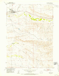
 1957 Bonneville1958 Print · USGSRailroad operations and water management define this Fremont County corridor in the late fifties. Genealogists and rail historians can trace the junction of the Chicago Burlington and Quincy near Bonneville and the Ford stop.3 unique versions available
 - 1958 Map of Thermopolis
 1958 Thermopolis1958 Print · USGSThe Bighorn Basin and Wind River Reservation are shown here in the late fifties, during a period of significant petroleum and agricultural growth. Genealogists and historians can trace rail-towns like Gebo, energy hubs like the Hamilton Dome Oil Field, and the layout of Fort Washakie.2 unique versions available
 - 1962 Map of Thermopolis
 1962 Thermopolis1962 Print · USGSThe Wind River and Bighorn basins are meticulously mapped in the early sixties, showing the vital irrigation and rail networks of the era. Genealogists and historians can locate specific landmarks like the Duncan Ranch School, the Wyoming Industrial Institute, and the Hamilton Dome oil field.
End of results
Showing maps 1-8 of 8
Top cities near Shoshoni
Frequently asked questions
- What are the different types of historical maps available for Shoshoni?
- What is the oldest map of Shoshoni?
- Where can I purchase historical maps of Shoshoni for my home or office?
- Where can I download high-res historical maps of Shoshoni?
- Are there historical topographic maps available for Shoshoni?
- Is there historical aerial imagery available for Shoshoni?
- Where are historical maps of Shoshoni sourced from?