
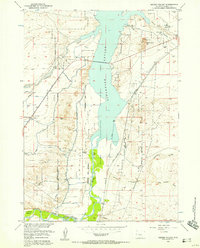
1951 Map of Hidden Valley
USGS Topo · Published 1953About this map
The Wind River Indian Reservation dominates this central Wyoming landscape, where the confluence of the Wind River and several major tributaries creates a complex network of waterways and irrigation infrastructure. The era's focus on land development is evident in the extensive water management systems, including the Fivemile Ditch, Pilot Canal, and various siphons and pipe lines that crisscross the valley. Cultural landmarks like the Valley View Store and Shoshoni City Cemetery provide touchpoints for local history, while the Chicago and Northwestern railroad tracks trace a vital transportation corridor through the rugged terrain of Hidden Valley. A notable geographic feature is the blue hachured area marking the proposed Boysen Reservoir, indicating the impending transformation of this basin. Geologic and industrial activity is represented by the Gravel Pit near the river, while natural drainages like Poison Creek and Muskrat Creek define the arid topography.
Find a feature on this map
20 named features on this map. Tap any name to fly to it.
Don’t see what you’re looking for? This feature index may not catch every label — zoom into the map to look around manually.
Map Details
Editions of this 1951 Hidden Valley Map
This is the sole edition of this map. No revisions or reprints were ever made.
Other maps of this area

1950 · Riverton East
USGS Topo · 1:24,000

1950 · Bonneville SW
USGS Topo · 1:24,000

1951 · Mexican Pass SE
USGS Topo · 1:24,000

1951 · Fuller Reservoir
USGS Topo · 1:24,000

1951 · Indian Butte
USGS Topo · 1:24,000

1951 · Bonneville
USGS Topo · 1:24,000

1951 · Shoshoni
USGS Topo · 1:24,000

1952 · Riverton NE
USGS Topo · 1:24,000

1955 · Thermopolis
USGS Topo · 1:250,000
1957 · Hidden Valley
USGS Topo · 1:24,000