
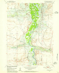
1950 Map of Bonneville SW
USGS Topo · Published 1952About this map
The Wind River Indian Reservation dominates the landscape of this 1950s survey, defined by the winding course of the Wind River and the stark elevation of Sand Mesa. This territory in Fremont County serves as a vital transportation corridor, where the Chicago Burlington and Quincy and Chicago and North Western railroads parallel the river’s path. The map records a transition in land use, showing scattered Windmills and Wells across the arid Sand Hills south of Badwater Creek. Industrial traces are evident near the reservation boundary at Emery and various Gravel Pits, while hydrological management is noted at the Gaging Sta along Cottonwood Creek. The intricate drainage network of Tough Creek and Birdseye Creek illustrates the complex topography surrounding the Big Horn landmark.
Find a feature on this map
22 named features on this map. Tap any name to fly to it.
Don’t see what you’re looking for? This feature index may not catch every label — zoom into the map to look around manually.
Map Details
Editions of this 1950 Bonneville SW Map
2 editions found
Other maps of this area

1951 · Mexican Pass SE
USGS Topo · 1:24,000

1951 · Boysen
USGS Topo · 1:24,000

1951 · Birdseye Pass
USGS Topo · 1:24,000

1951 · Morrison Canyon
USGS Topo · 1:24,000

1951 · Hidden Valley
USGS Topo · 1:24,000

1951 · Bonneville
USGS Topo · 1:24,000

1951 · Shoshoni
USGS Topo · 1:24,000

1952 · Riverton NE
USGS Topo · 1:24,000

1955 · Thermopolis
USGS Topo · 1:250,000
1957 · Hidden Valley
USGS Topo · 1:24,000