1900s (20th Century) Maps of Cokeville, Wyoming
Explore 7 historic maps of Cokeville from the 1900s (20th Century). These maps offer a rare glimpse into what life looked like during the 1900s — showing old roads, neighborhoods, homes, and landmarks that have changed or disappeared over time.
Whether you're researching your family's past, planning a metal detecting trip, or studying how Cokeville's landscape evolved across the 1900s, these high-resolution maps are a powerful tool for exploring the history of this region.
- Focus on a specific era: All maps on this page are from the 1900s, giving you a focused view of this time period.
- See what’s changed: Compare century-old streets, trails, and buildings to today's modern landscape using overlays and satellite layers.
- Research with precision: Use these maps for genealogy, historical research, land use analysis, or educational projects.
- View, download, or print: Maps are fully viewable online in high resolution, and can be downloaded or printed for your own records.
Start exploring Cokeville's history through authentic maps from the 1900s. This is your window into the past.
Cokeville, WY maps
(7)- 1936 Map of Cokeville
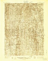 1936 Cokeville1936 Print · USGSWestern Wyoming in the mid-1930s reveals a landscape where pioneer history and rail infrastructure meet. Trace the routes of the Oregon Trail and Dempsey Trail past remote schools like Upper Hams Fork Sch and the Fontenelle Ranger Sta.
 - 1942 Map of Cokeville
 1942 Cokeville1942 Print · USGSWestern Wyoming migration routes are frozen in time on this survey of Lincoln County in the late thirties. Genealogists and historians can trace the physical paths of the Oregon Trail, find the Upper Hams Fork Sch, and locate remote outposts like Smiths Fork Guard Station.3 unique versions available
 - 1955 Map of Preston, 1968 Print
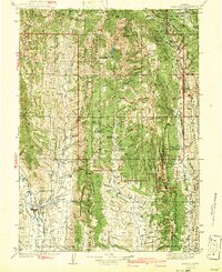
 1955 Preston1968 Print · USGSSoutheast Idaho and western Wyoming are shown in detail during the mid-fifties, from the high Bear River Range to the Green River Basin. Genealogists and collectors can trace the Union Pacific RR through historic towns like Preston, Montpelier, and Afton.3 unique versions available
 - 1958 Map of Preston
 1958 Preston1958 Print · USGSThe high valleys of the Idaho and Wyoming borderlands are captured here in the late fifties, showcasing a landscape of mountain ranching and phosphate mining. Genealogists and historians can locate early settlements like Chesterfield and Bedford or trace the Union Pacific rail lines serving Cokeville.2 unique versions available
 - 1962 Map of Preston
 1962 Preston1962 Print · USGSSoutheast Idaho and the Wyoming borderlands are captured here in the early sixties, a time of thriving agricultural valleys and mountain ranching. Researchers can trace the Union Pacific rail lines and find legacy settlements like Montpelier, Afton, and Preston.
 - 1967 Map of Cokeville, 1971 Print
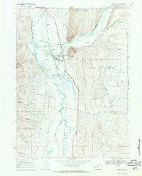 1967 Cokeville1971 Print · USGSThe Bear River valley in the late sixties reveals a landscape shaped by pioneer trails and the railroad. Researchers can trace the Emigrant Trail and Sublette Cutoff near the Union Pacific line and Cokeville.2 unique versions available
 - 1982 Map of Fontenelle Reservoir
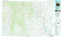 1982 Fontenelle Reservoir1982 Print · USGSWestern Wyoming's high country is captured here during the early eighties, showing the intersection of historic pioneer routes and modern water management. Genealogists and historians can trace the Emigrant Trail, Sublette Cutoff, and old sites like Rainbow Camp.2 unique versions available
End of results
Showing maps 1-7 of 7
Frequently asked questions
- What are the different types of historical maps available for Cokeville?
- What is the oldest map of Cokeville?
- Where can I purchase historical maps of Cokeville for my home or office?
- Where can I download high-res historical maps of Cokeville?
- Are there historical topographic maps available for Cokeville?
- Is there historical aerial imagery available for Cokeville?
- Where are historical maps of Cokeville sourced from?