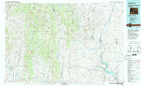
1982 Map of Fontenelle Reservoir
USGS Topo · Published 1982About this map
The Fontenelle Reservoir and the Green River anchor the eastern landscape of this early 1980s Western Wyoming survey, where high desert plateaus meet the foothills of the Bridger National Forest. Historically significant pathways cross this terrain, most notably the Emigrant Trail and the Sublette Cutoff, tracing the routes of 19th-century westward expansion through what is now Lincoln and Sublette counties. Small settlements and industrial outposts like La Barge and Dry Piney Camp dot the area, reflecting the region's reliance on river access and mineral resources.
Find a feature on this map
96 named features on this map. Tap any name to fly to it.
Don’t see what you’re looking for? This feature index may not catch every label — zoom into the map to look around manually.
Map Details
Editions of this 1982 Fontenelle Reservoir Map
2 editions found
Other maps of this area

1909 · Montpelier
USGS Topo · 1:125,000

1911 · Montpelier
USGS Topo · 1:125,000

1912 · Randolph
USGS Topo · 1:125,000

1915 · Crow Creek
USGS Topo · 1:62,500

1921 · Afton
USGS Topo · 1:125,000

1936 · Cokeville
USGS Topo · 1:96,000

1939 · Big Piney
USGS Topo · 1:125,000

1942 · Cokeville
USGS Topo · 1:125,000

1942 · Big Piney
USGS Topo · 1:125,000

1945 · Fort Hill
USGS Topo · 1:62,500