1980s Maps of Lance Creek, Wyoming
Explore 2 historic maps of Lance Creek from the 1980s. These maps offer a rare glimpse into what life looked like during the 1980s — showing old roads, neighborhoods, homes, and landmarks that have changed or disappeared over time.
Whether you're researching your family's past, planning a metal detecting trip, or studying how Lance Creek's landscape evolved across the 1980s, these high-resolution maps are a powerful tool for exploring the history of this region.
- Focus on a specific era: All maps on this page are from the 1980s, giving you a focused view of this time period.
- See what’s changed: Compare century-old streets, trails, and buildings to today's modern landscape using overlays and satellite layers.
- Research with precision: Use these maps for genealogy, historical research, land use analysis, or educational projects.
- View, download, or print: Maps are fully viewable online in high resolution, and can be downloaded or printed for your own records.
Start exploring Lance Creek's history through authentic maps from the 1980s. This is your window into the past.
Lance Creek, WY maps
(2)- 1981 Map of Lance Creek
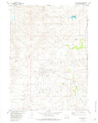 1981 Lance Creek1981 Print · USGSNiobrara County petroleum production is in full focus during the early eighties, showcasing the infrastructure of the Lance Creek Oil Field. Researchers can trace the development of West Lance Creek alongside industrial features like Landing Strips and numerous well sites.
 - 1981 Map of Lance Creek, 1983 Print
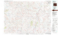 1981 Lance Creek1983 Print · USGSEastern Wyoming at the start of the 1980s reveals a high-plains landscape dominated by the energy industry and complex drainage systems. Researchers can trace the footprints of the Kaye Oil Field and Clareton Oil Field or follow the waters of the Cheyenne River and Robbers Roost Creek.
End of results
Showing maps 1-2 of 2
Frequently asked questions
- What are the different types of historical maps available for Lance Creek?
- What is the oldest map of Lance Creek?
- Where can I purchase historical maps of Lance Creek for my home or office?
- Where can I download high-res historical maps of Lance Creek?
- Are there historical topographic maps available for Lance Creek?
- Is there historical aerial imagery available for Lance Creek?
- Where are historical maps of Lance Creek sourced from?