1910s Maps of Dry Creek, Wyoming
Explore 2 historic maps of Dry Creek from the 1910s. These maps offer a rare glimpse into what life looked like during the 1910s — showing old roads, neighborhoods, homes, and landmarks that have changed or disappeared over time.
Whether you're researching your family's past, planning a metal detecting trip, or studying how Dry Creek's landscape evolved across the 1910s, these high-resolution maps are a powerful tool for exploring the history of this region.
- Focus on a specific era: All maps on this page are from the 1910s, giving you a focused view of this time period.
- See what’s changed: Compare century-old streets, trails, and buildings to today's modern landscape using overlays and satellite layers.
- Research with precision: Use these maps for genealogy, historical research, land use analysis, or educational projects.
- View, download, or print: Maps are fully viewable online in high resolution, and can be downloaded or printed for your own records.
Start exploring Dry Creek's history through authentic maps from the 1910s. This is your window into the past.
Dry Creek, WY maps
(2)- 1911 Map of Oregon Basin, 1975 Print
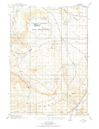 1911 Oregon Basin1975 Print · USGSThe high basin of Park County comes into focus just before the Great War, showing early ranching and mining efforts in the Wyoming desert. Genealogists can locate Sleeper's Ranch and Red Cabin, while historians can trace the Wiley Canal (Abandoned) and the early workings of the Wiley Mine.
 - 1913 Map of Oregon Basin
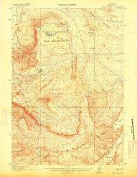 1913 Oregon Basin1913 Print · USGSPark County, Wyoming, appears here during a transformative era of early irrigation and mining development just before the First World War. Researchers can trace historic infrastructure like the Wiley Canal (Abandoned), the Eagle Mine, and the original Sleeper's Ranch.2 unique versions available
End of results
Showing maps 1-2 of 2
Top cities near Dry Creek
Frequently asked questions
- What are the different types of historical maps available for Dry Creek?
- What is the oldest map of Dry Creek?
- Where can I purchase historical maps of Dry Creek for my home or office?
- Where can I download high-res historical maps of Dry Creek?
- Are there historical topographic maps available for Dry Creek?
- Is there historical aerial imagery available for Dry Creek?
- Where are historical maps of Dry Creek sourced from?