Old Maps of Meeteetse, Wyoming
Explore 10 old maps of Meeteetse, spanning from 1911 to today. These high-resolution historic maps reveal how streets, neighborhoods, landmarks, and natural features evolved over time — perfect for genealogy, metal detecting, research, and local history exploration.
What you can do with these maps:
- See how Meeteetse changed over time: Compare historical maps to modern-day views to trace roads, homesites, rail lines & more.
- View detailed metadata: Each map includes creators, publishers, year, scale, and archive source.
- Overlay maps with satellite & LiDAR: Visualize the past alongside modern tools to explore terrain & human change.
- Trusted historical sources: Maps sourced from the USGS, Library of Congress, and other archives.
- Access maps your way: View online, download high-res files, or order prints for personal or research use.
Start exploring old maps of Meeteetse to uncover forgotten places, hidden landmarks, and the deep history beneath your feet.
Meeteetse, WY maps
(10)- 1911 Map of Meeteetse, 1957 Print
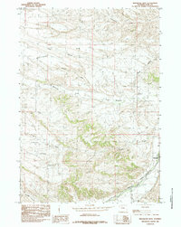
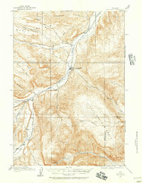 1911 Meeteetse1957 Print · USGSMeeteetse and the Bighorn Basin are captured here in the early twentieth century as ranching and early mining took hold. Researchers can trace the historic Cody Road and locate old landmarks like the Black Diamond Mine and Renner's Ranch.
 - 1913 Map of Meeteetse
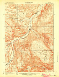 1913 Meeteetse1913 Print · USGSMeeteetse and the surrounding ranchlands are captured here in the years before World War I. Researchers can trace the early road network like Cody Road or locate historical sites such as Dumbell, Sunshine, and the Black Diamond Mine.3 unique versions available
 - 1955 Map of Cody, 1969 Print
 1955 Cody1969 Print · USGSThe Bighorn Basin and Absaroka Range meet in the mid-fifties, capturing a landscape defined by mountain wilderness and burgeoning oil fields. Trace family roots in Cody or Meeteetse, and locate industrial landmarks like the Elk Basin Oil and Gas Field and the Chicago Burlington and Quincy RR.2 unique versions available
 - 1958 Map of Cody
 1958 Cody1958 Print · USGSNorthwestern Wyoming at the peak of the mid-century energy and ranching boom shows a land of high peaks and oil basins. Researchers can trace the Chicago Burlington and Quincy rail lines through Greybull or locate the sprawling Elk Basin Oil and Gas Field.
 - 1962 Map of Cody
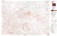
 1962 Cody1962 Print · USGSBig Horn Basin energy and agriculture define this mid-century look at Wyoming’s northern frontier. Local historians can trace the irrigation and rail networks connecting Cody and Powell to major energy sites like the Oregon Basin Oil Field.
 - 1982 Map of Basin, 1983 Print
 1982 Basin1983 Print · USGSBig Horn and Park counties in the early eighties were defined by the high-desert benches and the vital waters of the Bighorn River. Researchers can trace the rail-and-river economy through the Burlington Northern line and locate local landmarks like the Eagle Mine or the Bird Reservation at Loch-Katrine.
 - 1985 Map of Meeteetse East
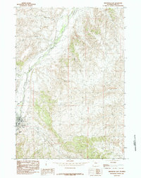 1985 Meeteetse East1985 Print · USGSMeeteetse and the Greybull River valley are captured in the mid-eighties before modern development altered the rural landscape. Local historians can trace ranching landmarks like Sleepers Ranch and the family history associated with Cemetery Hill.
 - 1985 Map of Meeteetse West
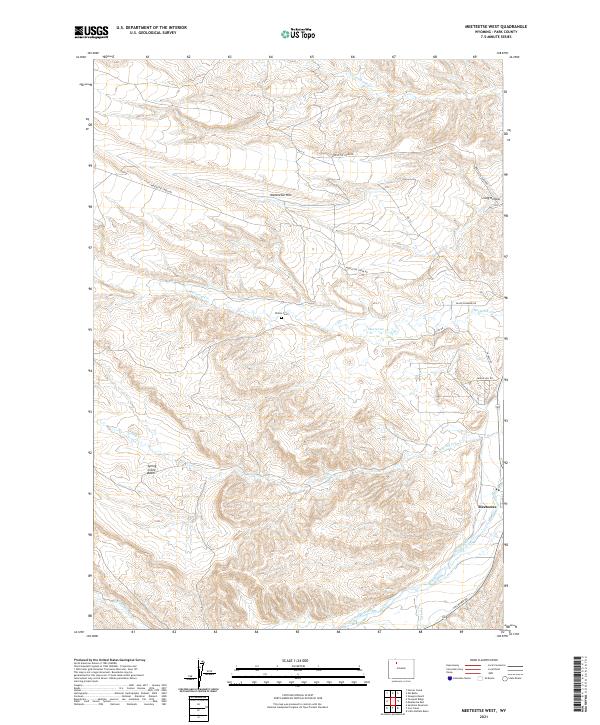
 1985 Meeteetse West1985 Print · USGSThe Greybull River valley and the town of Meeteetse are shown in the mid-1980s, documenting the ranching landscape before modern development. Researchers can trace the drainage patterns of Meeteetse Rim and locate the Gaging Sta along the Greybull River.
 - 2021 Map of Meeteetse West, 2021 Print
 2021 Meeteetse West2021 Print · USGSPark County, Wyoming, is captured here in the early 2020s as the high-plains landscape around Meeteetse continues its long ranching tradition. Researchers can locate family landmarks such as Wilson Cem and trace the winding course of the Greybull River and Meeteetse Cr.
 - 2021 Map of Meeteetse East, 2021 Print
 2021 Meeteetse East2021 Print · USGSMeeteetse sits at the crossroads of the Wyoming high desert and the Greybull River valley in this modern survey. Genealogists and local historians can map the town's residential core and the Meeteetse Cem, or trace drainage routes through Long Hollow and Fifteenmile Cr.
End of results
Showing maps 1-10 of 10
Frequently asked questions
- What are the different types of historical maps available for Meeteetse?
- What is the oldest map of Meeteetse?
- Where can I purchase historical maps of Meeteetse for my home or office?
- Where can I download high-res historical maps of Meeteetse?
- Are there historical topographic maps available for Meeteetse?
- Is there historical aerial imagery available for Meeteetse?
- Where are historical maps of Meeteetse sourced from?