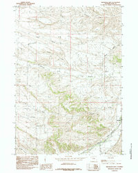
1985 Map of Meeteetse West
USGS Topo · Published 1985About this map
The Greybull River flows through the southern portion of this mid-1980s landscape, providing a critical water source in an area of high mesas and deep drainage cuts. The town of Meeteetse sits at the eastern edge of the sheet, where local roads follow the natural contours of the valley. To the north, the prominent Meeteetse Rim overlooks a complex network of seasonal waterways including Long Hollow and Wilson Draw, reflecting a topography where water flow has carved distinct features into the Wyoming basin. The survey captures the transition from the high rim down into the Spring Creek Basin, a wide geographic depression marked by numerous ephemeral branches like Spring Creek. A Gaging Sta near the river indicates the ongoing management of water resources in this ranching country, where the landscape is defined by the relationship between the elevated rimrock and the river bottom.
Find a feature on this map
12 named features on this map. Tap any name to fly to it.
Don’t see what you’re looking for? This feature index may not catch every label — zoom into the map to look around manually.
Map Details
Editions of this 1985 Meeteetse West Map
This is the sole edition of this map. No revisions or reprints were ever made.
Other maps of this area

1911 · Meeteetse
USGS Topo · 1:62,500

1911 · Oregon Basin
USGS Topo · 1:62,500

1913 · Oregon Basin
USGS Topo · 1:62,500

1913 · Meeteetse
USGS Topo · 1:62,500

1955 · Cody
USGS Topo · 1:250,000

1957 · Devils Tooth
USGS Topo · 1:62,500

1957 · Sunshine Reservoir
USGS Topo · 1:62,500

1958 · Cody
USGS Topo · 1:250,000

1962 · Cody
USGS Topo · 1:250,000

1980 · Carter Mountain
USGS Topo · 1:100,000