1900s (20th Century) Maps of Meeteetse, Wyoming
Explore 8 historic maps of Meeteetse from the 1900s (20th Century). These maps offer a rare glimpse into what life looked like during the 1900s — showing old roads, neighborhoods, homes, and landmarks that have changed or disappeared over time.
Whether you're researching your family's past, planning a metal detecting trip, or studying how Meeteetse's landscape evolved across the 1900s, these high-resolution maps are a powerful tool for exploring the history of this region.
- Focus on a specific era: All maps on this page are from the 1900s, giving you a focused view of this time period.
- See what’s changed: Compare century-old streets, trails, and buildings to today's modern landscape using overlays and satellite layers.
- Research with precision: Use these maps for genealogy, historical research, land use analysis, or educational projects.
- View, download, or print: Maps are fully viewable online in high resolution, and can be downloaded or printed for your own records.
Start exploring Meeteetse's history through authentic maps from the 1900s. This is your window into the past.
Meeteetse, WY maps
(8)- 1911 Map of Meeteetse, 1957 Print
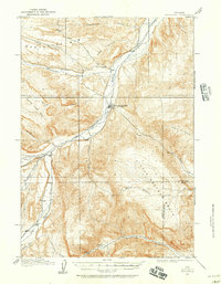 1911 Meeteetse1957 Print · USGSMeeteetse and the Bighorn Basin are captured here in the early twentieth century as ranching and early mining took hold. Researchers can trace the historic Cody Road and locate old landmarks like the Black Diamond Mine and Renner's Ranch.
 - 1913 Map of Meeteetse
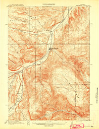 1913 Meeteetse1913 Print · USGSMeeteetse and the surrounding ranchlands are captured here in the years before World War I. Researchers can trace the early road network like Cody Road or locate historical sites such as Dumbell, Sunshine, and the Black Diamond Mine.3 unique versions available
 - 1955 Map of Cody, 1969 Print
 1955 Cody1969 Print · USGSThe Bighorn Basin and Absaroka Range meet in the mid-fifties, capturing a landscape defined by mountain wilderness and burgeoning oil fields. Trace family roots in Cody or Meeteetse, and locate industrial landmarks like the Elk Basin Oil and Gas Field and the Chicago Burlington and Quincy RR.2 unique versions available
 - 1958 Map of Cody
 1958 Cody1958 Print · USGSNorthwestern Wyoming at the peak of the mid-century energy and ranching boom shows a land of high peaks and oil basins. Researchers can trace the Chicago Burlington and Quincy rail lines through Greybull or locate the sprawling Elk Basin Oil and Gas Field.
 - 1962 Map of Cody
 1962 Cody1962 Print · USGSBig Horn Basin energy and agriculture define this mid-century look at Wyoming’s northern frontier. Local historians can trace the irrigation and rail networks connecting Cody and Powell to major energy sites like the Oregon Basin Oil Field.
 - 1982 Map of Basin, 1983 Print
 1982 Basin1983 Print · USGSBig Horn and Park counties in the early eighties were defined by the high-desert benches and the vital waters of the Bighorn River. Researchers can trace the rail-and-river economy through the Burlington Northern line and locate local landmarks like the Eagle Mine or the Bird Reservation at Loch-Katrine.
 - 1985 Map of Meeteetse East
 1985 Meeteetse East1985 Print · USGSMeeteetse and the Greybull River valley are captured in the mid-eighties before modern development altered the rural landscape. Local historians can trace ranching landmarks like Sleepers Ranch and the family history associated with Cemetery Hill.
 - 1985 Map of Meeteetse West
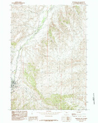
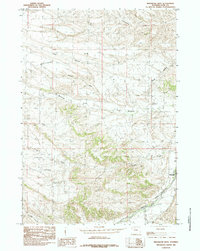 1985 Meeteetse West1985 Print · USGSThe Greybull River valley and the town of Meeteetse are shown in the mid-1980s, documenting the ranching landscape before modern development. Researchers can trace the drainage patterns of Meeteetse Rim and locate the Gaging Sta along the Greybull River.
End of results
Showing maps 1-8 of 8
Frequently asked questions
- What are the different types of historical maps available for Meeteetse?
- What is the oldest map of Meeteetse?
- Where can I purchase historical maps of Meeteetse for my home or office?
- Where can I download high-res historical maps of Meeteetse?
- Are there historical topographic maps available for Meeteetse?
- Is there historical aerial imagery available for Meeteetse?
- Where are historical maps of Meeteetse sourced from?