1900s (20th Century) Maps of Sheridan, Wyoming
Explore 12 historic maps of Sheridan from the 1900s (20th Century). These maps offer a rare glimpse into what life looked like during the 1900s — showing old roads, neighborhoods, homes, and landmarks that have changed or disappeared over time.
Whether you're researching your family's past, planning a metal detecting trip, or studying how Sheridan's landscape evolved across the 1900s, these high-resolution maps are a powerful tool for exploring the history of this region.
- Focus on a specific era: All maps on this page are from the 1900s, giving you a focused view of this time period.
- See what’s changed: Compare century-old streets, trails, and buildings to today's modern landscape using overlays and satellite layers.
- Research with precision: Use these maps for genealogy, historical research, land use analysis, or educational projects.
- View, download, or print: Maps are fully viewable online in high resolution, and can be downloaded or printed for your own records.
Start exploring Sheridan's history through authentic maps from the 1900s. This is your window into the past.
Sheridan, WY maps
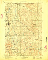
(12)- 1901 Map of Dayton
 1901 Dayton1901 Print · USGSSheridan County and the Montana borderlands are captured here at the turn of the century as the railroad reshapes the valley. Researchers can trace early settlements and ranching outposts like Slack, Beckton, and the Morrow Ranch along the Tongue River.5 unique versions available
 - 1909 Map of Sheridan, 1954 Print
 1909 Sheridan1954 Print · USGSSheridan and the surrounding northern Wyoming ranchlands are captured here in the first decade of the twentieth century. Genealogists can trace family holdings at Wagoner Ranch or Big Red Ranch, and locate early rail stations like Verona and Ulm.2 unique versions available
 - 1911 Map of Sheridan
 1911 Sheridan1911 Print · USGSSheridan and the surrounding northern Wyoming ranchlands are captured here during a period of rapid railroad expansion. Researchers can trace the Chicago Burlington and Quincy RR through Dietz and Verona, or locate early homesteads like Wagoner Ranch.2 unique versions available
 - 1955 Map of Sheridan, 1973 Print
 1955 Sheridan1973 Print · USGSThe Bighorn Mountains meet the Powder River Basin in the 1950s, a period when cattle ranching and coal mining defined the regional economy. Genealogists and historians can trace local landmarks like the Fort Mackenzie Veteran Hospital, the Monarch Coal Mine, and legacy operations such as the Beckton Stock Farm.2 unique versions available
 - 1958 Map of Sheridan
 1958 Sheridan1958 Print · USGSThe Bighorn Mountains meet the high plains in the mid-1950s, revealing a landscape of large-scale ranching and mineral extraction. Trace the legacy of early settlements and industry through the Kleenburn Coal Tipple, Beckton Stock Farm, and the Hidden Dome Oil & Gas Field.2 unique versions available
 - 1962 Map of Sheridan
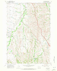
 1962 Sheridan1962 Print · USGSThe Big Horn Mountains and Powder River country are captured here in the early sixties as energy production and ranching shaped northern Wyoming. Researchers can locate specific sites like the Kleenburn Coal Tipple, Eaton Bros Ranch, and the Fort McKenzie Veteran Hospital.
 - 1964 Map of Hultz Draw, 1968 Print
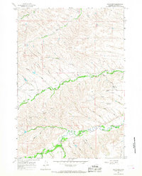 1964 Hultz Draw1968 Print · USGSSheridan County's high-plains landscape was defined by its intricate water systems and rural outposts in the 1960s. Genealogists and researchers can trace local landmarks like the Big Goose Sch, the Alliance Ditch, and the namesake Hultz Draw.3 unique versions available
 - 1967 Map of Big Horn, 1972 Print
 1967 Big Horn1972 Print · USGSSheridan County ranching and irrigation are captured here in the late sixties, centered on the community of Big Horn. Researchers can trace early infrastructure and land use through the Woodland Park Sch, the State Bird Farm, and numerous historic canals like Gerdel Ditch.3 unique versions available
 - 1968 Map of Sheridan, 1972 Print
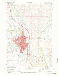 1968 Sheridan1972 Print · USGSSheridan enters the late sixties as a vital regional center shaped by the Burlington Northern railroad and Goose Creek. Researchers can locate the Sheridan Inn, the Veterans Adm Hospital, and family sites near Mt Hope Cem.3 unique versions available
 - 1970 Map of Burgess Junction, 1979 Print
 1970 Burgess Junction1979 Print · USGSThe Bighorn Mountains meet the Tongue River valley in the late 1970s, showcasing a landscape of high-altitude forest and foothill settlements. Genealogists and historians can trace the rail towns of Monarch and Ranchester or locate old mountain landmarks like Steamboat Point and Burgess Junction.
 - 1979 Map of Sheridan
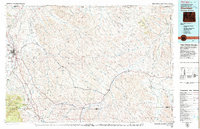 1979 Sheridan1979 Print · USGSSheridan and the surrounding ranching country are captured in the late seventies as the region balanced its frontier heritage with new energy development. Researchers can trace the path of the Burlington Northern railroad and locate historic landmarks like Massacre Hill and Lodge Trail Ridge.
 - 1979 Map of Burgess Junction
 1979 Burgess Junction1979 Print · USGSSheridan County and the Bighorn front are captured in the late seventies as the region balanced mountain wilderness with industrial growth. Local researchers can trace early transportation routes like the Burlington Northern rail line and locate old sites at Kleeburn and Monarch.
End of results
Showing maps 1-12 of 12
Top cities near Sheridan
Top neighborhoods of Sheridan
Frequently asked questions
- What are the different types of historical maps available for Sheridan?
- What is the oldest map of Sheridan?
- Where can I purchase historical maps of Sheridan for my home or office?
- Where can I download high-res historical maps of Sheridan?
- Are there historical topographic maps available for Sheridan?
- Is there historical aerial imagery available for Sheridan?
- Where are historical maps of Sheridan sourced from?