1960s Maps of Temple Creek Summer Home Area, Wyoming
Explore 2 historic maps of Temple Creek Summer Home Area from the 1960s. These maps offer a rare glimpse into what life looked like during the 1960s — showing old roads, neighborhoods, homes, and landmarks that have changed or disappeared over time.
Whether you're researching your family's past, planning a metal detecting trip, or studying how Temple Creek Summer Home Area's landscape evolved across the 1960s, these high-resolution maps are a powerful tool for exploring the history of this region.
- Focus on a specific era: All maps on this page are from the 1960s, giving you a focused view of this time period.
- See what’s changed: Compare century-old streets, trails, and buildings to today's modern landscape using overlays and satellite layers.
- Research with precision: Use these maps for genealogy, historical research, land use analysis, or educational projects.
- View, download, or print: Maps are fully viewable online in high resolution, and can be downloaded or printed for your own records.
Start exploring Temple Creek Summer Home Area's history through authentic maps from the 1960s. This is your window into the past.
Temple Creek Summer Home Area, WY maps
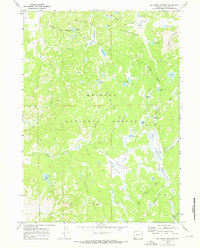
(2)- 1961 Map of Lander
 1961 Lander1961 Print · USGSThe high peaks and desert basins of central Wyoming appear here in the early sixties, showing the landscape of the Shoshone Indian Reservation and the Wind River Range. Researchers can trace the path of the Oregon Trail and locate early settlements like Lander and the mining remains at South Pass City.2 unique versions available
 - 1969 Map of Big Sandy Opening, 1973 Print
 1969 Big Sandy Opening1973 Print · USGSSublette County in the late sixties reveals a primitive landscape of the Wind River Range before modern development intensified. Researchers can trace historic stock routes and early recreation sites like the Big Sandy Driveway and Big Sandy Campground.4 unique versions available
End of results
Showing maps 1-2 of 2
Frequently asked questions
- What are the different types of historical maps available for Temple Creek Summer Home Area?
- What is the oldest map of Temple Creek Summer Home Area?
- Where can I purchase historical maps of Temple Creek Summer Home Area for my home or office?
- Where can I download high-res historical maps of Temple Creek Summer Home Area?
- Are there historical topographic maps available for Temple Creek Summer Home Area?
- Is there historical aerial imagery available for Temple Creek Summer Home Area?
- Where are historical maps of Temple Creek Summer Home Area sourced from?