1900s (20th Century) Maps of Elk, Wyoming
Explore 7 historic maps of Elk from the 1900s (20th Century). These maps offer a rare glimpse into what life looked like during the 1900s — showing old roads, neighborhoods, homes, and landmarks that have changed or disappeared over time.
Whether you're researching your family's past, planning a metal detecting trip, or studying how Elk's landscape evolved across the 1900s, these high-resolution maps are a powerful tool for exploring the history of this region.
- Focus on a specific era: All maps on this page are from the 1900s, giving you a focused view of this time period.
- See what’s changed: Compare century-old streets, trails, and buildings to today's modern landscape using overlays and satellite layers.
- Research with precision: Use these maps for genealogy, historical research, land use analysis, or educational projects.
- View, download, or print: Maps are fully viewable online in high resolution, and can be downloaded or printed for your own records.
Start exploring Elk's history through authentic maps from the 1900s. This is your window into the past.
Elk, WY maps
(7)- 1901 Map of Grand Teton, 1909 Print
 1901 Grand Teton1909 Print · USGSThe Teton valley was a land of homesteads and river crossings at the turn of the century. Genealogists can trace early settler families at Grovont and numerous holdings like Cunningham Ranch or locate the historic Menor Ferry crossing.4 unique versions available
 - 1955 Map of Driggs, 1967 Print
 1955 Driggs1967 Print · USGSEastern Idaho and Western Wyoming appear at a mid-century crossroads as the river valleys were fully settled and the high peaks protected. Genealogists and researchers can trace the rail towns of Rexburg and Driggs or follow the Snake River from Irwin to the Palisades Reservoir.3 unique versions available
 - 1958 Map of Driggs
 1958 Driggs1958 Print · USGSThe high Teton peaks and Snake River valleys are captured here in the mid-fifties, showing the region's agricultural and wilderness boundaries. Researchers can trace the Union Pacific rail corridor through Rexburg or locate early settlements like Clementsville and Tetonia.2 unique versions available
 - 1962 Map of Driggs
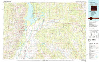
 1962 Driggs1962 Print · USGSThe Idaho-Wyoming borderlands are captured here in the early sixties, showing the peaks and valleys of the northern Rockies. Genealogists and historians can trace rail lines like the Union Pacific RR and isolated outposts like the National Elk Refuge or the Fort Hall Indian Reservation.
 - 1968 Map of Moran, 1972 Print
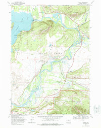 1968 Moran1972 Print · USGSGrand Teton National Park and the winding Snake River appear here during the late sixties. Researchers can trace established legacy sites like Cunningham Cabin and active working landscapes including Triangle X Ranch and Wolff Ranch.2 unique versions available
 - 1981 Map of Jackson Lake
 1981 Jackson Lake1981 Print · USGSGrand Teton National Park and its surrounding wilderness are captured here in the early eighties. Researchers can trace high-altitude peaks like Mount Moran down to valley landmarks such as Jackson Lake Lodge, Colter Bay Village, and the Jackson Hole Airport.2 unique versions available
 - 1996 Map of Moran, 1998 Print
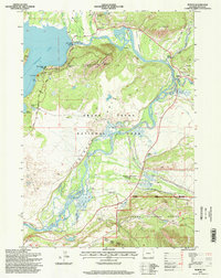 1996 Moran1998 Print · USGSThe Teton valley in the mid-1990s reveals a landscape where historic homesteads and park infrastructure coexist along the Snake River. Researchers can trace the footprints of the Triangle X Ranch, the Cunningham Cabin, and the community around Moran Junction.
End of results
Showing maps 1-7 of 7
Frequently asked questions
- What are the different types of historical maps available for Elk?
- What is the oldest map of Elk?
- Where can I purchase historical maps of Elk for my home or office?
- Where can I download high-res historical maps of Elk?
- Are there historical topographic maps available for Elk?
- Is there historical aerial imagery available for Elk?
- Where are historical maps of Elk sourced from?