1980s Maps of Three River Junction, Wyoming
Explore 2 historic maps of Three River Junction from the 1980s. These maps offer a rare glimpse into what life looked like during the 1980s — showing old roads, neighborhoods, homes, and landmarks that have changed or disappeared over time.
Whether you're researching your family's past, planning a metal detecting trip, or studying how Three River Junction's landscape evolved across the 1980s, these high-resolution maps are a powerful tool for exploring the history of this region.
- Focus on a specific era: All maps on this page are from the 1980s, giving you a focused view of this time period.
- See what’s changed: Compare century-old streets, trails, and buildings to today's modern landscape using overlays and satellite layers.
- Research with precision: Use these maps for genealogy, historical research, land use analysis, or educational projects.
- View, download, or print: Maps are fully viewable online in high resolution, and can be downloaded or printed for your own records.
Start exploring Three River Junction's history through authentic maps from the 1980s. This is your window into the past.
Three River Junction, WY maps
(2)- 1982 Map of Yellowstone National Park South, 1983 Print
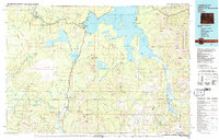 1982 Yellowstone National Park South1983 Print · USGSThe southern reaches of Yellowstone and the Teton Wilderness are captured here in the early 1980s, showcasing a landscape of high plateaus and river headwaters. Trace the historic paths of the Two Ocean Pass Trail or locate remote outposts like Flagg Ranch and Grant Village.
 - 1986 Map of Trischman Knob
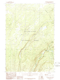 1986 Trischman Knob1986 Print · USGSYellowstone's wild southwestern corner is captured in the mid-1980s, centered on the river junctions and falls of the Bechler region. Trace the Pack Trail past Three River Junction to find remote landmarks like Tendoy Falls, Wahhi Falls, and Ragged Falls.
End of results
Showing maps 1-2 of 2
Frequently asked questions
- What are the different types of historical maps available for Three River Junction?
- What is the oldest map of Three River Junction?
- Where can I purchase historical maps of Three River Junction for my home or office?
- Where can I download high-res historical maps of Three River Junction?
- Are there historical topographic maps available for Three River Junction?
- Is there historical aerial imagery available for Three River Junction?
- Where are historical maps of Three River Junction sourced from?