1950s Maps of Three River Junction, Wyoming
Explore 3 historic maps of Three River Junction from the 1950s. These maps offer a rare glimpse into what life looked like during the 1950s — showing old roads, neighborhoods, homes, and landmarks that have changed or disappeared over time.
Whether you're researching your family's past, planning a metal detecting trip, or studying how Three River Junction's landscape evolved across the 1950s, these high-resolution maps are a powerful tool for exploring the history of this region.
- Focus on a specific era: All maps on this page are from the 1950s, giving you a focused view of this time period.
- See what’s changed: Compare century-old streets, trails, and buildings to today's modern landscape using overlays and satellite layers.
- Research with precision: Use these maps for genealogy, historical research, land use analysis, or educational projects.
- View, download, or print: Maps are fully viewable online in high resolution, and can be downloaded or printed for your own records.
Start exploring Three River Junction's history through authentic maps from the 1950s. This is your window into the past.
Three River Junction, WY maps
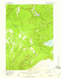
(3)- 1955 Map of Ashton, 1967 Print
 1955 Ashton1967 Print · USGSThe Greater Yellowstone ecosystem is captured here during the mid-1950s, showing the high plateaus and remote gateway towns of Idaho and Montana. Researchers can trace the Union Pacific line to Ashton or locate small settlements like Squirrel and Grainville.4 unique versions available
 - 1956 Map of Old Faithful, 1958 Print
 1956 Old Faithful1958 Print · USGSYellowstone's geothermal heart is captured during the mid-fifties, centered on the active basins of the Firehole River. Trace the early layout of the Old Faithful Inn or follow backcountry routes to the Lone Star Geyser and Shoshone Lake.2 unique versions available
 - 1958 Map of Ashton
 1958 Ashton1958 Print · USGSGreater Yellowstone and the eastern Idaho borderlands appear here in the mid-1950s as rail and road networks connected remote mountain basins. Trace the Union Pacific route through Ashton or locate early outposts like Last Chance, Squirrel, and West Yellowstone.
End of results
Showing maps 1-3 of 3
Frequently asked questions
- What are the different types of historical maps available for Three River Junction?
- What is the oldest map of Three River Junction?
- Where can I purchase historical maps of Three River Junction for my home or office?
- Where can I download high-res historical maps of Three River Junction?
- Are there historical topographic maps available for Three River Junction?
- Is there historical aerial imagery available for Three River Junction?
- Where are historical maps of Three River Junction sourced from?