
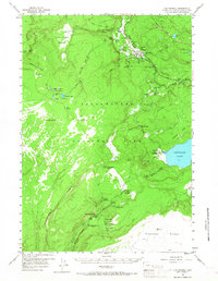
1956 Map of Old Faithful
USGS Topo · Published 1958About this map
The Firehole River carves through a geothermal landscape defined by active thermal features and dense coniferous forest in this mid-century survey of Yellowstone National Park. Central to the map is the Upper Geyser Basin, home to the world-renowned Old Faithful geyser and the Old Faithful Inn. This area shows a concentration of thermal landmarks including the Morning Glory Pool, Grotto Geyser, and the colorful Sapphire Pool within Biscuit Basin. Beyond the developed thermal areas, the map reveals the wilderness character of the Madison Plateau and the remote Shoshone Geyser Basin on the shores of Shoshone Lake. The drainage patterns of the Bechler River in the south are punctuated by numerous cataracts, including Twister Falls and Tendoy Falls, illustrating the dramatic vertical drops across the Continental Divide.
Find a feature on this map
54 named features on this map. Tap any name to fly to it.
Don’t see what you’re looking for? This feature index may not catch every label — zoom into the map to look around manually.
Map Details
Editions of this 1956 Old Faithful Map
2 editions found
Other maps of this area

1885 · Gallatin
USGS Topo · 1:125,000

1885 · Gallatin
USGS Topo · 1:125,000

1886 · Shoshone
USGS Topo · 1:125,000

1888 · Shoshone
USGS Topo · 1:125,000

1895 · Shoshone
USGS Topo · 1:125,000

1901 · Shoshone
USGS Topo · 1:125,000

1901 · Gallatin
USGS Topo · 1:125,000

1908 · Gallatin
USGS Topo · 1:125,000

1908 · Shoshone
USGS Topo · 1:125,000

1911 · Shoshone
USGS Topo · 1:125,000