1990s Maps of Uinta County, Wyoming
Explore 16 historic maps of Uinta County from the 1990s. These maps offer a rare glimpse into what life looked like during the 1990s — showing old roads, neighborhoods, homes, and landmarks that have changed or disappeared over time.
Whether you're researching your family's past, planning a metal detecting trip, or studying how Uinta County's landscape evolved across the 1990s, these high-resolution maps are a powerful tool for exploring the history of this region.
- Focus on a specific era: All maps on this page are from the 1990s, giving you a focused view of this time period.
- See what’s changed: Compare century-old streets, trails, and buildings to today's modern landscape using overlays and satellite layers.
- Research with precision: Use these maps for genealogy, historical research, land use analysis, or educational projects.
- View, download, or print: Maps are fully viewable online in high resolution, and can be downloaded or printed for your own records.
Start exploring Uinta County's history through authentic maps from the 1990s. This is your window into the past.
Uinta County, WY maps
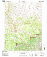
(16)- 1991 Map of Wahsatch
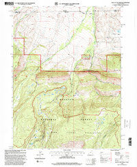
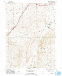 1991 Wahsatch1991 Print · USGSThe high mountain passes of the Utah-Wyoming border were still defined by historic transit routes and energy infrastructure in the early nineties. Genealogists and historians can trace the EMIGRANT TRAIL past The Needles and the old settlement at Wahsatch.
 - 1991 Map of Murphy Ridge
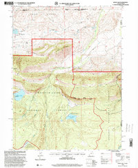
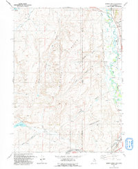 1991 Murphy Ridge1991 Print · USGSRich County, Utah, and the Wyoming borderlands are captured here in the early nineties, showing a landscape of high-altitude ranching and energy extraction. Genealogists and researchers can trace the settlement at Almy, locate the Almy Cem, and follow the winding Bear River through this complex border terrain.
 - 1991 Map of Porcupine Ridge
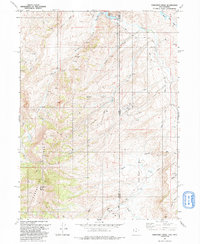 1991 Porcupine Ridge1991 Print · USGSThe high borderlands of Summit County and Wyoming are captured here in the early nineties, revealing a landscape defined by energy exploration. You can trace the development of the local Oil Field and find specific landmarks like the Barker Reservoir, Porcupine Mtn, and numerous Oil Wells.
 - 1991 Map of Neponset Reservoir NE
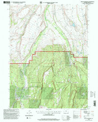
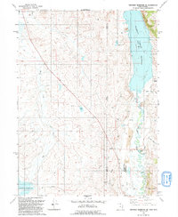 1991 Neponset Reservoir NE1991 Print · USGSThe high borderlands of Utah and Wyoming come into focus in the early 1990s, where the Bear River feeds large-scale irrigation projects. Genealogists and local historians can trace landmarks like Wyoming Downs, Murphy Ridge, and the Chapman Canal.
 - 1996 Map of Hoop Lake, 2000 Print
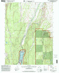
 1996 Hoop Lake2000 Print · USGSHigh-altitude borderlands in the Uintas appear here in the mid-nineties as the wilderness and forest boundaries meet. Researchers can trace remote resource infrastructure like the Landing Strip at Gregory Basin and the spillway at Hoop Lake.
 - 1998 Map of Meeks Cabin Reservoir, 2001 Print
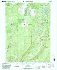
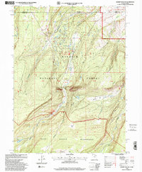
 1998 Meeks Cabin Reservoir2001 Print · USGSHigh in the Uinta Mountains during the late nineties, this survey documents the vital water infrastructure and forest management of the Wyoming wilderness. Locate family landmarks like the Meeks Cabin (Historical Site), the Uinta County Youth Camp, and the winding Blacks Fork.
 - 1998 Map of Elizabeth Mountain, 2001 Print
 1998 Elizabeth Mountain2001 Print · USGSHigh-altitude wilderness in the late nineties covers the border between Summit County and Wyoming. Researchers can trace forest management and mountain landmarks like the Mill Creek Guard Sta, Elizabeth Pass, and the Table Top plateau.
 - 1998 Map of Bridger Lake, 2001 Print
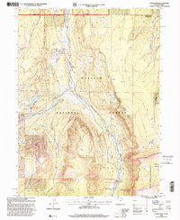
 1998 Bridger Lake2001 Print · USGSThe High Uintas at the turn of the millennium show a landscape of alpine reservoirs and remote forest stations along the Wyoming-Utah border. Researchers can locate historic backcountry sites like Hewinta FS Sta, the isolated Cem, and the extensive High Line Trail.
 - 1998 Map of Red Hole, 2001 Print
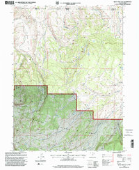
 1998 Red Hole2001 Print · USGSThe high country of Summit County comes into focus in the late nineties, showing the managed lands of the Wasatch National Forest. Genealogists and historians can trace family-named outposts like Angard Ranch and Rigby Ranch along the headwaters of Chalk Creek.2 unique versions available
 - 1998 Map of Buck Fever Ridge, 2001 Print
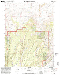
 1998 Buck Fever Ridge2001 Print · USGSUinta County was characterized by high-elevation ranching and forest management in the late nineties. Genealogists and historians can trace family-named sites like Perry Ranch and remote landmarks including Cowboy Cabin Park and Lambs Meadow.
 - 1998 Map of Seven Tree Flat, 2001 Print
 1998 Seven Tree Flat2001 Print · USGSThe high borderlands of the Uinta and Summit County line are captured in the late nineties, documenting the remote drainages of the Wasatch National Forest. Outdoorsmen and researchers can trace the old forest tracks near Seven Tree Flat, Grassy Lakes, and the winding West Fork of the Bear River.
 - 1998 Map of Deadman Mountain, 2001 Print
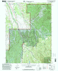 1998 Deadman Mountain2001 Print · USGSThe high timber and river valleys of the Uinta Mountains are captured in the late nineties as this borderland balanced ranching with forest recreation. Researchers can trace the Hilliard East Fork Canal or locate sites like Island Ranch and the Hill Air Force Base Recreation Camp.
 - 1998 Map of Hole In The Rock, 2001 Print
 1998 Hole In The Rock2001 Print · USGSHigh-altitude forest and wilderness areas along the Utah-Wyoming border are captured here in the late nineties. Researchers can trace the Hole in the Rock Guard Station, explore Coal Mine Hill, and locate the Hoop Lake Campground.
 - 1998 Map of Gilbert Peak NE, 2001 Print
 1998 Gilbert Peak NE2001 Print · USGSThe high Uinta backcountry meets the industrial edge of the Bridger Lake Oil Field at the turn of the millennium. Outdoor enthusiasts and land researchers can trace the roads to Bridger Lake Oil Field or the remote trails of the High Uintas Wilderness.
 - 1998 Map of Lyman Lake, 2001 Print
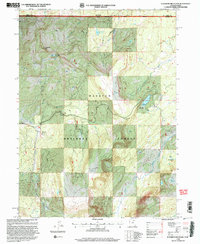
 1998 Lyman Lake2001 Print · USGSThe High Uintas wilderness at the turn of the millennium shows a landscape defined by headwater basins and forest management. Trace early mountain history at the Old Blacks Fork Commissary or locate remote landmarks like the East Fork Blacks Fork Guard Station and Lyman Lake.
 - 1998 Map of Table Mountain, 2001 Print
 1998 Table Mountain2001 Print · USGSUinta County high country in the late nineties shows a landscape of forest management and industrial exploration within the Wasatch National Forest. Researchers can trace water sources from Big Spring to the Henrys Fork or locate old industrial markers like the Oil Well (Dry) and Gravel Pit.
End of results
Showing maps 1-16 of 16
Top cities of Uinta County
- Evanston historical maps
- Lyman historical maps
- Mountain View historical maps
- Bear River historical maps
Frequently asked questions
- What are the different types of historical maps available for Uinta County?
- What is the oldest map of Uinta County?
- Where can I purchase historical maps of Uinta County for my home or office?
- Where can I download high-res historical maps of Uinta County?
- Are there historical topographic maps available for Uinta County?
- Is there historical aerial imagery available for Uinta County?
- Where are historical maps of Uinta County sourced from?