1970s Maps of Uinta County, Wyoming
Explore 4 historic maps of Uinta County from the 1970s. These maps offer a rare glimpse into what life looked like during the 1970s — showing old roads, neighborhoods, homes, and landmarks that have changed or disappeared over time.
Whether you're researching your family's past, planning a metal detecting trip, or studying how Uinta County's landscape evolved across the 1970s, these high-resolution maps are a powerful tool for exploring the history of this region.
- Focus on a specific era: All maps on this page are from the 1970s, giving you a focused view of this time period.
- See what’s changed: Compare century-old streets, trails, and buildings to today's modern landscape using overlays and satellite layers.
- Research with precision: Use these maps for genealogy, historical research, land use analysis, or educational projects.
- View, download, or print: Maps are fully viewable online in high resolution, and can be downloaded or printed for your own records.
Start exploring Uinta County's history through authentic maps from the 1970s. This is your window into the past.
Uinta County, WY maps
(4)- 1972 Map of Seven Tree Flat, 1974 Print
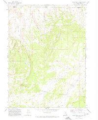 1972 Seven Tree Flat1974 Print · USGSHigh in the Uinta Mountains in the early seventies, this survey captures the remote headwaters and forest lands of the Utah-Wyoming border. Researchers can trace the courses of the West Fork Bear River and Chalk Creek or navigate the Jeep Trails around Seven Tree Flat.2 unique versions available
 - 1972 Map of Deadman Mountain, 1974 Print
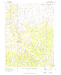
 1972 Deadman Mountain1974 Print · USGSThe high Uinta wilderness in the early seventies showcases a landscape of alpine ranching and complex irrigation canals. Researchers can trace the routes of the Hilliard Canal, find the Burts-Miller Ranch, or locate the Hill Air Force Base Recreation Camp.2 unique versions available
 - 1972 Map of Red Hole, 1974 Print
 1972 Red Hole1974 Print · USGSThe high timber and ranchlands of the Utah-Wyoming border are captured here in the early seventies as the region supported remote sheep and cattle operations. Researchers can locate family-named landmarks like Rigby Ranch and Anzard Ranch or trace the trails near Joyce Lake.
 - 1979 Map of Kemmerer, 1980 Print
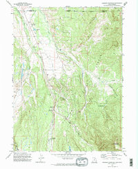
 1979 Kemmerer1980 Print · USGSLincoln County in the late seventies reveals an economy built on coal and rail between the ridges of the Overthrust Belt. Trace the industrial landscape from the Elkol Strip Mine to the historic Union Pacific line and Fossil Butte National Monument.2 unique versions available
End of results
Showing maps 1-4 of 4
Top cities of Uinta County
- Evanston historical maps
- Lyman historical maps
- Mountain View historical maps
- Bear River historical maps
Frequently asked questions
- What are the different types of historical maps available for Uinta County?
- What is the oldest map of Uinta County?
- Where can I purchase historical maps of Uinta County for my home or office?
- Where can I download high-res historical maps of Uinta County?
- Are there historical topographic maps available for Uinta County?
- Is there historical aerial imagery available for Uinta County?
- Where are historical maps of Uinta County sourced from?