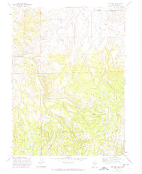
1972 Map of Red Hole
USGS Topo · Published 1974About this map
Rigby Ranch and Anzard Ranch stand as isolated outposts along the remote waterways of the high country in the early 1970s. This survey, grounded in field checks from 1972, documents a rugged intersection of the Wasatch National Forest where the state lines of Wyoming and Utah meet the county boundaries of Uinta and Summit. The landscape is defined by the sharp descent from Porcupine Ridge into the drainage of Chalk Creek, a network of seasonal streams including the East Fork and Middle Fork.
Find a feature on this map
16 named features on this map. Tap any name to fly to it.
Don’t see what you’re looking for? This feature index may not catch every label — zoom into the map to look around manually.
Map Details
Editions of this 1972 Red Hole Map
This is the sole edition of this map. No revisions or reprints were ever made.
Other maps of this area

1885 · Salt Lake
USGS Topo · 1:250,000

1885 · Uinta
USGS Topo · 1:250,000

1900 · Coalville
USGS Topo · 1:125,000

1901 · Hayden Peak
USGS Topo · 1:125,000

1903 · Hayden Peak
USGS Topo · 1:125,000

1903 · Coalville
USGS Topo · 1:125,000

1954 · Salt Lake City
USGS Topo · 1:250,000

1954 · Ogden
USGS Topo · 1:250,000

1958 · Ogden
USGS Topo · 1:250,000

1958 · Salt Lake City
USGS Topo · 1:250,000