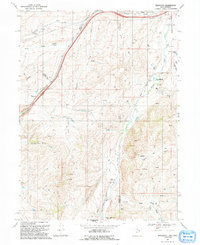
1991 Map of Wahsatch
USGS Topo · Published 1991About this map
Emigrant Trail traces a historic route through this high-altitude landscape on the Utah-Wyoming border, following the natural passage through Echo Canyon. This 1991 revision of mid-century aerial surveys captures the rugged transition between the Rich and Summit county lines. The settlement at Wahsatch serves as a focal point near the northern end of the canyon, while Wasatch sits just across the state line in Wyoming.
Find a feature on this map
29 named features on this map. Tap any name to fly to it.
Don’t see what you’re looking for? This feature index may not catch every label — zoom into the map to look around manually.
Map Details
Editions of this 1991 Wahsatch Map
This is the sole edition of this map. No revisions or reprints were ever made.
Other maps of this area

1954 · Ogden
USGS Topo · 1:250,000

1958 · Ogden
USGS Topo · 1:250,000

1960 · Ogden
USGS Topo · 1:250,000

1965 · Evanston
USGS Topo · 1:24,000

1965 · Myers Reservoir
USGS Topo · 1:24,000

1965 · Millis
USGS Topo · 1:24,000

1968 · Wahsatch
USGS Topo · 1:24,000
1968 · Porcupine Ridge
USGS Topo · 1:24,000

1968 · Shearing Corral
USGS Topo · 1:24,000

1968 · Mc Kay Hollow
USGS Topo · 1:24,000