
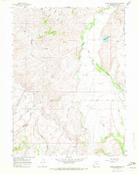
1965 Map of Myers Reservoir
USGS Topo · Published 1968About this map
Bear River winds through this corner of Uinta County, shaping the agricultural and topographic character of the region during the mid-1960s. The map centers on the Myers Reservoir and the diverse network of drainages that feed into the river valley, including Cottonwood Creek and Mill Creek. The landscape is defined by its series of named hollows and draws, such as Clifton Hollow and Harding Hollow, which suggest a terrain carved by seasonal water flow and livestock grazing patterns. High-elevation features like Cove Meadow and the numerous springs, including Randal Springs, indicate a reliance on natural water sources for the local ranching economy. Transportation is represented by the Chalk Creek Road and an industrial Pipeline that traverses the northern sections, reflecting the early infrastructure of this high-desert environment.
Find a feature on this map
25 named features on this map. Tap any name to fly to it.
Don’t see what you’re looking for? This feature index may not catch every label — zoom into the map to look around manually.
Map Details
Editions of this 1965 Myers Reservoir Map
2 editions found
Other maps of this area

1885 · Salt Lake
USGS Topo · 1:250,000

1885 · Uinta
USGS Topo · 1:250,000

1900 · Coalville
USGS Topo · 1:125,000

1901 · Hayden Peak
USGS Topo · 1:125,000

1903 · Hayden Peak
USGS Topo · 1:125,000

1903 · Coalville
USGS Topo · 1:125,000

1954 · Salt Lake City
USGS Topo · 1:250,000

1954 · Ogden
USGS Topo · 1:250,000

1958 · Ogden
USGS Topo · 1:250,000

1958 · Salt Lake City
USGS Topo · 1:250,000