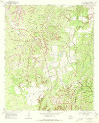
1969 Map of A B C Creek
USGS Topo · Published 1972About this map
Abc and the small settlement at Harmony anchor this West Texas landscape along the border of Kent and Stonewall Counties. The terrain is defined by the winding paths of ABC Creek and Stinking Creek, which carve through the Adair Canyon and past the distinctive Tater Hills. This era of the late 1960s shows a landscape heavily influenced by the petroleum industry, evidenced by the extensive Rough Draw North Oil Field and numerous scattered Oil Well symbols and drill holes across the quadrangle. Beyond energy extraction, the map reveals a rural infrastructure of isolation and utility, featuring several private Landing Strips and a network of pipelines. Natural and man-made water sources, such as SoRelle Lake, provide vital points of interest in a region characterized by the dramatic Devils Backbone ridge. This survey documents the intersection of traditional ranching geography with mid-century industrial expansion in a quiet corner of the Texas plains.
Find a feature on this map
16 named features on this map. Tap any name to fly to it.
Don’t see what you’re looking for? This feature index may not catch every label — zoom into the map to look around manually.
Map Details
Editions of this 1969 A B C Creek Map
This is the sole edition of this map. No revisions or reprints were ever made.
Other maps of this area

1893 · Roby
USGS Topo · 1:125,000

1926 · Snyder 1-a
USGS Topo · 1:48,000

1926 · Roby 2-b
USGS Topo · 1:48,000

1931 · Rotan
USGS Topo · 1:62,500

1932 · Camp Springs
USGS Topo · 1:62,500

1954 · Lubbock
USGS Topo · 1:250,000

1954 · Big Spring
USGS Topo · 1:250,000

1958 · Big Spring
USGS Topo · 1:250,000

1968 · Double Mountains
USGS Topo · 1:24,000

1968 · Peacock
USGS Topo · 1:24,000