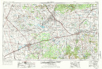
1958 Map of Big Spring
USGS Topo · Published 1958About this map
The mid-century West Texas landscape is defined here by the rapid expansion of the petroleum industry and the vital infrastructure of the Texas and Pacific and Santa Fe railroads. Numerous energy hubs like the Kelly-Snyder Oil Field, Diamond M Oil Field, and Westbrook Oil Field dominate the map, connected by an extensive network of an Underground pipeline. These industrial sites sit alongside landmarks of the earlier frontier, such as Muchakooago Peak and the Signal Mountains.
Find a feature on this map
165 named features on this map. Tap any name to fly to it.
Don’t see what you’re looking for? This feature index may not catch every label — zoom into the map to look around manually.
Map Details
Editions of this 1958 Big Spring Map
This is the sole edition of this map. No revisions or reprints were ever made.
Historical Maps of Big Spring Through Time
3 maps found