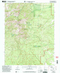
2001 Map of Abajo Peak
USGS Topo · Published 2004About this map
Abajo Mountains dominate this high-altitude landscape, rising to prominent summits like Abajo Peak and Horsehead Peak within the Manti-La Sal National Forest. This 2001 revision illustrates a complex network of high-country drainage and water management, including the Camp Jackson Reservoir and an aqueduct system. Settlement is sparse in this portion of the Monticello Ranger District, centered on locations like the Blue Mtn Ranch and a remote Gaging Sta. Local history is captured in specialized sites such as a lone Grave and the Gold Queen Basin, while numerous mountain crossings like Cooley Pass and Dickson Pass indicate the historical importance of pack and wagon travel through the canyons of Devil Canyon and Bulldog Canyon.
Find a feature on this map
40 named features on this map. Tap any name to fly to it.
Don’t see what you’re looking for? This feature index may not catch every label — zoom into the map to look around manually.
Map Details
Editions of this 2001 Abajo Peak Map
This is the sole edition of this map. No revisions or reprints were ever made.
Other maps of this area

1886 · Abajo
USGS Topo · 1:250,000

1892 · Abajo
USGS Topo · 1:250,000

1893 · Abajo
USGS Topo · 1:250,000

1935 · Elk Ridge
USGS Topo · 1:96,000

1940 · Elk Ridge
USGS Topo · 1:125,000

1954 · Elk Ridge 1 NE
USGS Topo · 1:24,000

1954 · Elk Ridge 1 SE
USGS Topo · 1:24,000
1954 · Mt Linnaeus
USGS Topo · 1:62,500

1955 · Verdure 2 SE
USGS Topo · 1:24,000

1955 · Verdure 3 NE
USGS Topo · 1:24,000