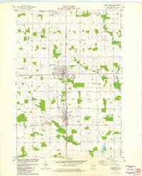
1981 Map of Abbotsford
USGS Topo · Published 1982About this map
The boundary between Clark and Marathon counties bisects this 1981 survey, tracing the shared identity of Abbotsford and Colby. The landscape is defined by the Soo Line railroad and a grid of rural routes like Colonial Drive and Townhall Road, supporting a dairy-country economy of farmsteads and gravel pits. Community landmarks of the era include the Colby-Abbotsford Airport, a High School in both towns, and a Drive-in Theater situated along the main corridor. The topography is shaped by the headwaters of several drainages, including the North Fork Popple River and West Branch Big Eau Pleine River. Notable for genealogists are the Colby and Holton cemeteries, along with localized place names such as Mayville and Hull townships, which preserve the political and social geography of this central Wisconsin dairy region.
Find a feature on this map
33 named features on this map. Tap any name to fly to it.
Don’t see what you’re looking for? This feature index may not catch every label — zoom into the map to look around manually.
Map Details
Editions of this 1981 Abbotsford Map
This is the sole edition of this map. No revisions or reprints were ever made.
Other maps of this area

1902 · Marathon
USGS Topo · 1:125,000

1951 · Athens
USGS Topo · 1:48,000

1951 · Medford
USGS Topo · 1:48,000

1953 · Abbotsford
USGS Topo · 1:48,000

1953 · Stratford
USGS Topo · 1:48,000

1953 · Eau Claire
USGS Topo · 1:250,000

1953 · Rice Lake
USGS Topo · 1:250,000

1958 · Eau Claire
USGS Topo · 1:250,000

1959 · Rice Lake
USGS Topo · 1:250,000

1963 · Stratford
USGS Topo · 1:62,500