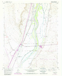
1952 Map of Abeytas
USGS Topo · Published 1986About this map
The Rio Grande valley corridor defines this mid-century survey, revealing a landscape of ancient land grants and intricate irrigation engineering. Settlements like Abeytas and Las Nutrias are situated along the eastern bank, supported by an extensive network of waterways including the San Juan Canal and Las Nutrias Drain. To the west, the Atchison Topeka And Santa Fe railroad cuts through the valley, passing the village of Bernardo and an abandoned oil well near the base of Picho Hill. The map documents the overlap of traditional community life, represented by the San Isidro Church and Abeytas Cemetery, with federal conservation efforts at the Sevilleta National Wildlife Refuge. The numerous gaging stations along the river and the Rio Puerco junction highlight the constant management of water resources in this desert environment.
Find a feature on this map
36 named features on this map. Tap any name to fly to it.
Don’t see what you’re looking for? This feature index may not catch every label — zoom into the map to look around manually.
Map Details
Editions of this 1952 Abeytas Map
4 editions found
Other maps of this area

1916 · La Joya
USGS Topo · 1:125,000

1952 · La Joya NW
USGS Topo · 1:24,000

1952 · San Anacia
USGS Topo · 1:24,000

1952 · Belen SW
USGS Topo · 1:24,000

1952 · Black Butte
USGS Topo · 1:24,000

1952 · La Joya
USGS Topo · 1:24,000

1952 · Turn
USGS Topo · 1:24,000

1952 · Veguita
USGS Topo · 1:24,000

1952 · Becker SW
USGS Topo · 1:24,000

1952 · Abeytas
USGS Topo · 1:24,000