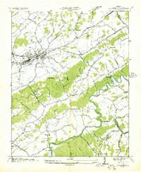
1935 Map of Abingdon
USGS Topo · Published 1935About this map
Abingdon serves as the primary hub of activity in this mid-1930s survey, showing a dense network of streets and rail infrastructure. The Norfolk and Western Railway cuts through the landscape, linking the town to surrounding settlements like McConnell and the Washington County Farm. Water power remains a visible legacy of local industry at Stone Mill on Town Creek and Parks Mill along the South Fork Holston River, which joins the Middle Fork Holston River in the south.
Find a feature on this map
72 named features on this map. Tap any name to fly to it.
Don’t see what you’re looking for? This feature index may not catch every label — zoom into the map to look around manually.
Map Details
Editions of this 1935 Abingdon Map
This is the sole edition of this map. No revisions or reprints were ever made.
Other maps of this area

1891 · Abingdon
USGS Topo · 1:125,000

1894 · Abingdon
USGS Topo · 1:125,000

1897 · Bristol
USGS Topo · 1:125,000

1902 · Bristol
USGS Topo · 1:125,000

1909 · Abingdon
USGS Topo · 1:96,000

1911 · Abingdon
USGS Topo · 1:125,000

1918 · Carterton
USGS Topo · 1:62,500

1934 · Holston Valley
USGS Topo · 1:24,000

1934 · Brumley
USGS Topo · 1:24,000

1934 · Wyndale
USGS Topo · 1:24,000