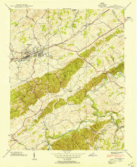
1938 Map of Abingdon
USGS Topo · Published 1954About this map
The town of Abingdon serves as the focal point for this pre-war survey, showing the community just as the Norfolk and Western railway corridor and the Lee Highway cemented it as a regional transportation hub. The landscape is defined by the prominent Knobs and the winding courses of the Middle Fork Holston River and South Fork Holston River. Rural life is meticulously documented through an array of local landmarks, including the County Prison Farm, several milling operations like Stone Mill, and community centers such as Camp Glenrochie. Local genealogists will find significant value in the distribution of small schools and churches, from Shiloh Sch in the south to Washington Chapel in the north, along with family-named landmarks like Keller Cem and Denton Ford that predate major modern developments.
Find a feature on this map
59 named features on this map. Tap any name to fly to it.
Don’t see what you’re looking for? This feature index may not catch every label — zoom into the map to look around manually.
Map Details
Editions of this 1938 Abingdon Map
This is the sole edition of this map. No revisions or reprints were ever made.
Other maps of this area

1891 · Abingdon
USGS Topo · 1:125,000

1894 · Abingdon
USGS Topo · 1:125,000

1897 · Bristol
USGS Topo · 1:125,000

1902 · Bristol
USGS Topo · 1:125,000

1909 · Abingdon
USGS Topo · 1:96,000

1911 · Abingdon
USGS Topo · 1:125,000

1918 · Carterton
USGS Topo · 1:62,500

1934 · Holston Valley
USGS Topo · 1:24,000

1934 · Brumley
USGS Topo · 1:24,000

1934 · Wyndale
USGS Topo · 1:24,000