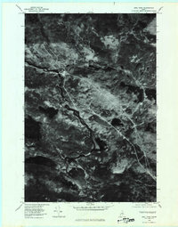
1978 Map of Abol Pond
USGS Topo · Published 1981About this map
The West Branch Penobscot River defines the western corridor of this Maine landscape, captured during a 1978 aerial survey. The orthophoto format provides a high-contrast view of the dense forests and interconnected waterways that characterize this part of Piscataquis County. To the north, the slopes of Abol Mountain rise above Abol Pond, while the eastern portion of the sheet is marked by the twin basins of Upper Togue Pond and Lower Togue Pond.
Find a feature on this map
8 named features on this map. Tap any name to fly to it.
Don’t see what you’re looking for? This feature index may not catch every label — zoom into the map to look around manually.
Map Details
Editions of this 1978 Abol Pond Map
This is the sole edition of this map. No revisions or reprints were ever made.
Other maps of this area

1927 · Katahdin
USGS Topo · 1:48,000

1930 · Katahdin
USGS Topo · 1:62,500

1949 · Katahdin
USGS Topo · 1:62,500

1951 · Norcross
USGS Topo · 1:62,500

1952 · Jo-Mary Mountain
USGS Topo · 1:62,500

1954 · Harrington Lake
USGS Topo · 1:62,500

1954 · Millinocket
USGS Topo · 1:250,000

1958 · Millinocket
USGS Topo · 1:250,000

1960 · Millinocket
USGS Topo · 1:250,000
1978 · Trout Mountain
USGS Topo · 1:24,000