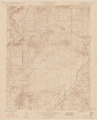
1947 Map of Academy
USGS Topo · Published 1947About this map
The Academy Granite Quarry anchors the southeastern landscape of this Fresno County survey, reflecting the local mineral extraction economy just after the war. The settlement of Academy sits nearby, serving as a focal point for a region characterized by family-run operations like Blasingame Ranch and Shide Ranch. Topographically, the area is defined by the prominent Table Mountain and Corlew Mountain, with numerous seasonal drainages including Little Dry Creek and Dry Creek carving through the terrain. Educational and civic infrastructure is represented by the Sentinel Sch and the McKenzie Fire Camp, while transportation routes such as Tollhouse Road and Millerton Road provide vital connections between the foothills and the valley. A notable detail for historians is the marking of the Fresno Kern Canal Construction, capturing a specific moment in California's hydraulic development.
Find a feature on this map
30 named features on this map. Tap any name to fly to it.
Don’t see what you’re looking for? This feature index may not catch every label — zoom into the map to look around manually.
Map Details
Editions of this 1947 Academy Map
2 editions found
Other maps of this area

1904 · Kaiser
USGS Topo · 1:125,000

1912 · Mariposa
USGS Topo · 1:125,000

1916 · Sulphur Springs
USGS Topo · 1:24,000

1919 · Sulphur Springs
USGS Topo · 1:31,680

1920 · Orangedale School
USGS Topo · 1:24,000

1922 · Round Mountain
USGS Topo · 1:31,680

1922 · Trimmer
USGS Topo · 1:96,000

1922 · Friant
USGS Topo · 1:31,680

1923 · Academy
USGS Topo · 1:31,680

1923 · Orangedale School
USGS Topo · 1:31,680