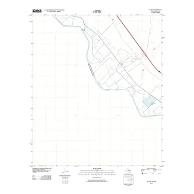
2010 Map of Acala
USGS Topo · Published 2010About this map
The Rio Grande serves as the international boundary between the United States and Mexico in this 2010 depiction of Hudspeth County. The landscape is defined by an intricate network of irrigation and drainage infrastructure, including the Cooke Drain, Upper River Drain, and the United States of America Mexico River Drain. These channels support the agricultural valley surrounding the small settlement of Acala, where local life is traced along Acala Rd and Soto Rd. The presence of the Texas No Name Number 47 Dam and the sprawling Alamo Arroyo highlights the regional focus on water management in an arid environment. Near the river, McCaskills Crossing and the rail point of Iser mark historical transit corridors through the valley. This survey provides a clear look at the borderlands just before significant modern changes in fencing and infrastructure altered the visual character of the river's edge.
Find a feature on this map
17 named features on this map. Tap any name to fly to it.
Don’t see what you’re looking for? This feature index may not catch every label — zoom into the map to look around manually.
Map Details
Editions of this 2010 Acala Map
This is the sole edition of this map. No revisions or reprints were ever made.
Other maps of this area

1894 · Fort Hancock
USGS Topo · 1:125,000

1896 · Rio Grande
USGS Topo · 1:125,000

1941 · Tornillo
USGS Topo · 1:62,500

1943 · Fort Hancock
USGS Topo · 1:62,500
1943 · McNary
USGS Topo · 1:62,500
1945 · Tornillo
USGS Topo · 1:62,500

1953 · El Paso
USGS Topo · 1:250,000

1954 · Van Horn
USGS Topo · 1:250,000

1958 · Van Horn
USGS Topo · 1:250,000

1959 · El Paso
USGS Topo · 1:250,000