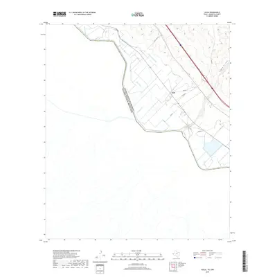
2019 Map of Acala
USGS Topo · Published 2019About this map
The Rio Grande serves as the international boundary between the United States of America and Mexico in this arid borderland survey. On the Texas side, the settlement of Acala is the primary focal point, surrounded by a complex network of irrigation and drainage infrastructure vital to the regional economy. This intricate system includes the Hudspeth Main Canal, Kelly Lateral, and the Upper Drain, which managed water flow across the river valley in the late 2010s. The landscape north of the river is marked by local transit routes such as Alameda and Alamo Lake Rd, while the desert terrain to the east is punctuated by the Alamo Arroyo. Local landmarks like the Miller Spur and Acala Lateral illustrate the specific engineering required to sustain agriculture and habitation in the Hudspeth County desert environment.
Find a feature on this map
18 named features on this map. Tap any name to fly to it.
Don’t see what you’re looking for? This feature index may not catch every label — zoom into the map to look around manually.
Map Details
Editions of this 2019 Acala Map
This is the sole edition of this map. No revisions or reprints were ever made.
Other maps of this area

1894 · Fort Hancock
USGS Topo · 1:125,000

1896 · Rio Grande
USGS Topo · 1:125,000

1941 · Tornillo
USGS Topo · 1:62,500

1943 · Fort Hancock
USGS Topo · 1:62,500
1943 · McNary
USGS Topo · 1:62,500
1945 · Tornillo
USGS Topo · 1:62,500

1953 · El Paso
USGS Topo · 1:250,000

1954 · Van Horn
USGS Topo · 1:250,000

1958 · Van Horn
USGS Topo · 1:250,000

1959 · El Paso
USGS Topo · 1:250,000