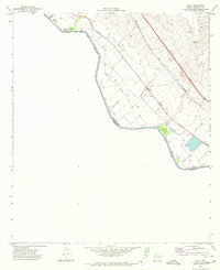
1972 Map of Acala
USGS Topo · Published 1974About this map
Agricultural irrigation and international transit dominate this stretch of the Rio Grande River borderland during the early 1970s. The settlement of Acala serves as a focal point for a complex network of water management features, including the Hudspeth Main Canal and various distributors like the Acala Lateral and Alamo Feeder. This infrastructure supported the valley's farming operations in a landscape otherwise defined by the dry wash of Alamo Arroyo and the upland Gravel Pits.
Find a feature on this map
22 named features on this map. Tap any name to fly to it.
Don’t see what you’re looking for? This feature index may not catch every label — zoom into the map to look around manually.
Map Details
Editions of this 1972 Acala Map
This is the sole edition of this map. No revisions or reprints were ever made.
Other maps of this area

1894 · Fort Hancock
USGS Topo · 1:125,000

1896 · Rio Grande
USGS Topo · 1:125,000

1941 · Tornillo
USGS Topo · 1:62,500

1943 · Fort Hancock
USGS Topo · 1:62,500
1943 · McNary
USGS Topo · 1:62,500
1945 · Tornillo
USGS Topo · 1:62,500

1953 · El Paso
USGS Topo · 1:250,000

1954 · Van Horn
USGS Topo · 1:250,000

1958 · Van Horn
USGS Topo · 1:250,000

1959 · El Paso
USGS Topo · 1:250,000