
1948 Map of Achilles
USGS Topo · Published 1948About this map
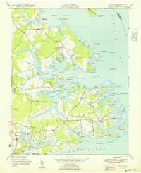
Guinea Neck and the intricate peninsulas of Gloucester County are captured here in the years following the Second World War. The landscape is defined by its maritime reliance, centered on the Severn River and the sweeping waters of Mobjack Bay. Small waterfront settlements like Achilles, Maryus, and Bena are linked by winding roads that terminate at local landmarks like Severn Wharf and Roanes Wharf. The importance of the coastal economy is evident through the numerous lights and beacons, including the Severn River Lt and Perrin River Entrance Lt, which guided vessel traffic through the complex estuaries.
Find a feature on this map
81 named features on this map. Tap any name to fly to it.
Don’t see what you’re looking for? This feature index may not catch every label — zoom into the map to look around manually.
Map Details
Editions of this 1948 Achilles Map
2 editions found
Other maps of this area

1906 · Williamsburg
USGS Topo · 1:62,500

1907 · Yorktown
USGS Topo · 1:62,500

1907 · Hampton
USGS Topo · 1:62,500

1916 · Mathews
USGS Topo · 1:62,500

1917 · Mathews
USGS Topo · 1:62,500

1943 · Yorktown
USGS Topo · 1:62,500

1943 · Richmond
USGS Topo · 1:250,000

1944 · Yorktown
USGS Topo · 1:24,000

1944 · Messick
USGS Topo · 1:24,000

1944 · Harris Grove
USGS Topo · 1:24,000