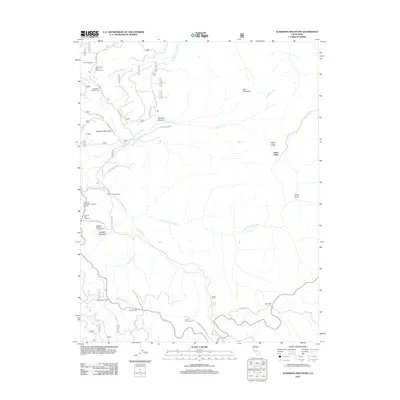
2012 Map of Ackerson Mountain
USGS Topo · Published 2012About this map
Ackerson Mountain and the surrounding Sierra Nevada highlands define this section of Yosemite National Park and the Stanislaus National Forest as they appeared in 2012. The landscape is a network of montane meadows and vital watersheds, including Ackerson Meadow and Hodgdon Meadow, which drain into the Middle Tuolumne River and the S Fork Tuolumne River. Evidence of land management and recreation is visible through sites like the Big Oak Flat District Ranger Office and the Crane Flat Lookout, alongside established camping areas such as the Middlefork Campground and Diamond O Boy Scout Camp. Historic ranching and agricultural footprints remain at Hazel Green Ranch and Peach Growers. High-elevation landmarks like the Tunnel Tree and Gin Flat sit along the winding corridor of Tioga Pass Rd, illustrating the intersection of natural preservation and early 21st-century access roads.
Find a feature on this map
58 named features on this map. Tap any name to fly to it.
Don’t see what you’re looking for? This feature index may not catch every label — zoom into the map to look around manually.
Map Details
Editions of this 2012 Ackerson Mountain Map
This is the sole edition of this map. No revisions or reprints were ever made.
Other maps of this area

1897 · Yosemite
USGS Topo · 1:125,000

1900 · Yosemite
USGS Topo · 1:125,000

1903 · Yosemite
USGS Topo · 1:125,000

1909 · Yosemite
USGS Topo · 1:125,000

1947 · El Portal
USGS Topo · 1:24,000

1947 · Mariposa
USGS Topo · 1:250,000

1947 · El Portal
USGS Topo · 1:62,500
1947 · Kinsley
USGS Topo · 1:24,000

1948 · Mariposa
USGS Topo · 1:250,000
1949 · Kinsley
USGS Topo · 1:24,000