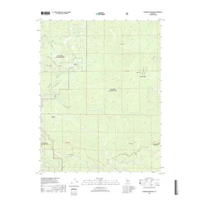
2018 Map of Ackerson Mountain
USGS Topo · Published 2018About this map
Aspen Valley and the high Sierra Nevada meadows serve as central landmarks in this documentation of the borderlands between Stanislaus National Forest and Yosemite National Park. The landscape is defined by its drainage basins, where the Middle Tuolumne River and the S Fork Tuolumne River cut through steep terrain near Ackerson Mtn. Historical transit corridors are well-represented, showing the winding path of the Old Tioga Road and the Old Big Oak Flat Road (Gentry Rd) as they move through high-altitude clearings like Crane Flat and Gin Flat. These roads and trails, including the S Fork Tuolumne River Trail, trace the legacy of early access to the California high country. The map also captures the transition from Tuolumne into Mariposa County, specifically along Crocker Ridge, offering a clear view of the wilderness interface that remains critical for modern conservation and resource management.
Find a feature on this map
38 named features on this map. Tap any name to fly to it.
Don’t see what you’re looking for? This feature index may not catch every label — zoom into the map to look around manually.
Map Details
Editions of this 2018 Ackerson Mountain Map
This is the sole edition of this map. No revisions or reprints were ever made.
Other maps of this area

1897 · Yosemite
USGS Topo · 1:125,000

1900 · Yosemite
USGS Topo · 1:125,000

1903 · Yosemite
USGS Topo · 1:125,000

1909 · Yosemite
USGS Topo · 1:125,000

1947 · El Portal
USGS Topo · 1:24,000

1947 · Mariposa
USGS Topo · 1:250,000

1947 · El Portal
USGS Topo · 1:62,500
1947 · Kinsley
USGS Topo · 1:24,000

1948 · Mariposa
USGS Topo · 1:250,000
1949 · Kinsley
USGS Topo · 1:24,000