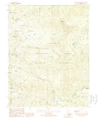
1990 Map of Ackerson Mountain
USGS Topo · Published 1990About this map
Hazel Green Ranch and the isolated Peach Growers settlement sit at the western edge of this high-country landscape, where the Stanislaus National Forest meets Yosemite National Park. The topography is defined by the deep canyons of the Middle Fork Tuolumne River and its various tributaries, including Ackerson Creek and Crane Creek. The transition from forest service land to protected wilderness is marked by the Yosemite Wilderness boundary, which encompasses the high ridges of Crocker Ridge and peaks like Ackerson Mountain.
Find a feature on this map
34 named features on this map. Tap any name to fly to it.
Don’t see what you’re looking for? This feature index may not catch every label — zoom into the map to look around manually.
Map Details
Editions of this 1990 Ackerson Mountain Map
This is the sole edition of this map. No revisions or reprints were ever made.
Other maps of this area

1897 · Yosemite
USGS Topo · 1:125,000

1900 · Yosemite
USGS Topo · 1:125,000

1903 · Yosemite
USGS Topo · 1:125,000

1909 · Yosemite
USGS Topo · 1:125,000

1947 · El Portal
USGS Topo · 1:24,000

1947 · Mariposa
USGS Topo · 1:250,000

1947 · El Portal
USGS Topo · 1:62,500
1947 · Kinsley
USGS Topo · 1:24,000

1948 · Mariposa
USGS Topo · 1:250,000
1949 · Kinsley
USGS Topo · 1:24,000