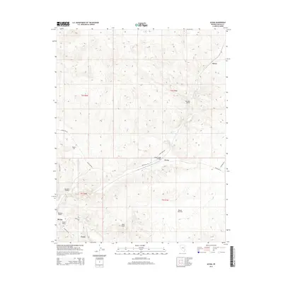
2014 Map of Acoma
USGS Topo · Published 2014About this map
Clover Cr carves a deep path through the high desert of Lincoln County, defining the movement of water and travelers through this arid landscape. The corridor serves as a focal point for small settlements like Acoma and Barclay, where the availability of water from sources such as Acoma Spring and North Spring made habitation possible. The map reveals a network of canyons and flats, including Clover Creek Canyon and Panaca Flat, which dictate the placement of roads like Beaver Dam Rd. This topography suggests a history of livestock ranching and sparse rural settlement, where proximity to reliable springs was the primary driver of development. In the southern portion of the sheet, Joseco sits near Clover Valley, marking a point where the terrain transitions toward Mathews Canyon. The distribution of these named landmarks indicates a landscape where life and transport are closely tied to the few natural drainages and mountain passes.
Find a feature on this map
28 named features on this map. Tap any name to fly to it.
Don’t see what you’re looking for? This feature index may not catch every label — zoom into the map to look around manually.
Map Details
Editions of this 2014 Acoma Map
This is the sole edition of this map. No revisions or reprints were ever made.
Other maps of this area

1885 · Pioche
USGS Topo · 1:250,000

1886 · Pioche
USGS Topo · 1:250,000

1954 · Caliente
USGS Topo · 1:250,000

1958 · Docs Pass
USGS Topo · 1:24,000

1959 · Caliente
USGS Topo · 1:250,000
1972 · Uvada
USGS Topo · 1:24,000
1972 · Mosey Mtn
USGS Topo · 1:24,000
1972 · Acoma
USGS Topo · 1:24,000
1972 · Dow Mountain
USGS Topo · 1:24,000
1972 · Pine Park
USGS Topo · 1:24,000